Tag Archives: 66 Fridays

Petrified Forest National Park sketch by Chandler O'Leary

Park rangers of the Mother Road

This post is part of an ongoing series called 66 Fridays, which explores the wonders of old Route 66. Click on the preceding “66 Fridays” link to view all posts in the series, or visit the initial overview post here.

The last post was a big fat tribute to the National Park Service, which celebrated its centennial yesterday. So it’s only fitting to spend today telling you about Petrified Forest National Park, which is the exact center of the Venn Diagram between the national parks and Route 66. In fact, it’s the only national park to contain a section of the original Mother Road.

Petrified Forest National Park sketch by Chandler O'Leary

Of course, even if you didn’t know anything about Route 66, Petrified Forest is still infinitely worth visiting. There is the namesake petrified wood, of course, but it’s the landscapes that touched this artist’s soul.

Petrified Forest National Park sketch by Chandler O'Leary

Around every bend in the road was some new desert vista, each one vastly different than the one before. And with every passing cloud the light changed, essentially remaking the land in a totally new image, all within minutes.

Petrified Forest National Park and Route 66 sketch by Chandler O'Leary

And just when you’ve all but forgotten what brought you here, you crest a hill and see a telltale line of telephone poles, still marching westward to the horizon.

Save

Plaza Cafe sketch by Chandler O'Leary

Time-tested tables

This post is part of an ongoing series called 66 Fridays, which explores the wonders of old Route 66. Click on the preceding “66 Fridays” link to view all posts in the series, or visit the initial overview post here.

Next time you’re in New Mexico to admire the hollyhocks, you’ll be sure to work up an appetite. And Route 66 is dotted with some of the best lunch spots in the Land of Enchantment. My favorite is probably the Plaza Cafe, the oldest recipe in Santa Fe (yes, Route 66 goes through Santa Fe…or it did, anyway; that’s a story for another day). I didn’t know that fact when we walked in, but it makes sense: both the food and the decor make this place a keeper.

El Camino Dining Room sketch by Chandler O'Leary

Downstate a bit in Albuquerque is another Route 66 relic that is still alive and well. You might recognize it from my earlier post featuring its sister property across the street. Like the Plaza Cafe, this place is quintessentially New Mexican, inside and out.

El Camino Dining Room sketch by Chandler O'Leary

El Camino was chosen for us by some local friends, and it turns out they knew us well. From the impeccably preserved interior to the killa-dilla sopapillas, I was ready to move in by the end.

Save

Save

Route 66 sketch by Chandler O'Leary

A flash of intuition

This post is part of an ongoing series called 66 Fridays, which explores the wonders of old Route 66. Click on the preceding “66 Fridays” link to view all posts in the series, or visit the initial overview post here.

There are few Route 66 landmarks more iconic than the art installation known as Cadillac Ranch, so the Tailor and I were really looking forward to seeing it in person. Unfortunately, however, long before we reached Amarillo we knew we’d lose the race for daylight. To make matters worse, a big thunderstorm was rapidly approaching from the west, the intermittent flashes of lightning coming ever closer, ever more quickly. Not exactly ideal weather to go fumbling around in the dark in search of roadside attractions. After all, it’s not like Cadillac Ranch is in the center of town—it’s out in the middle of an unmarked field, and I had a sneaking suspicion there were no floodlights trained on those cars.

The Tailor really wanted to stop anyway, and said, “Surely it’s lit after dark. It’s so famous!” I told him I didn’t think so—according to our maps we were within spitting distance of it, and there was nothing but inky black out there. Besides, the Texas Panhandle is so flat that if it were lit at all, we would have seen it from miles away.

I’m sorry to say I was right about that: it’s not lit. At all. It’s not marked in any way—at least, not by any method that could be discerned by headlight. We drove back and forth a few times on the mile-long stretch of beat-up frontage road to which I’d narrowed down the location, while I peered through the passenger-side window into the darkness, hoping a flash of lightning might give us a clue. Finally I broke down and, for the one and only time on our entire Route 66 trip, consulted the GPS map on my phone to see if we’d found the right place. With the one available bar of mobile service, our insistence on paper maps was at least vindicated: we had gotten the location precisely right.

“This is the spot, ” I said. “Can’t see anything, but we’re looking right at it.”

“Wait,” he answered, “maybe we’ll catch a glimpse of it in the storm.”

We waited. A few heartbeats of silence.

And then: CRACK.

Route 66 sketch by Chandler O'Leary

A fork of lightning, directly in front of us, not half a mile ahead. The flash illuminated ten unmistakeable silhouettes for a split second that felt like an eternity.

We looked at each other and simultaneously burst into nervous cackling, our eyes wide, the hairs on the napes of our necks standing on end.

Save

Route 66 sketch by Chandler O'Leary

Bridge over troubled water

This post is part of an ongoing series called 66 Fridays, which explores the wonders of old Route 66. Click on the preceding “66 Fridays” link to view all posts in the series, or visit the initial overview post here.

Route 66 was commissioned during something of a golden age of American infrastructure design. Thanks to various building booms and organizations like the WPA, the highway is studded with functional architecture that is also incredibly beautiful. One shining example is the magnificent Colorado Street Bridge in Pasadena.

Curving gracefully across the Arroyo Seco that divides Los Angeles from its inner-ring suburbs, the bridge was once the tallest concrete span on earth. Sadly, this may be what inspired the bridge’s more well-known moniker: Suicide Bridge. Over a hundred suicides have taken place there over the years—the vast majority of them during the Great Depression. With so many deaths to its name, the bridge also has a reputation for ghost sightings and other haunted tales.

I knew none of this on the day I crossed (and sketched) the Arroyo. To me, the bridge was just a stunning welcome to Los Angeles, the last major city on Route 66. I guess it’s a fitting way to cross over into the City of Angels.

Route 66 sketch by Chandler O'Leary

Fill ‘er up

This post is part of an ongoing series called 66 Fridays, which explores the wonders of old Route 66. Click on the preceding “66 Fridays” link to view all posts in the series, or visit the initial overview post here.

Polly want a pit stop?

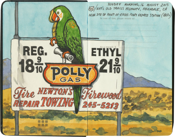
If you’re going to take a road trip, at some point you’re going to need to refuel. And nobody knows how to fill your tank like the folks on Route 66. Of course, since the route crosses a big swath of American oil country, you’ll know that the milk of the Mother Road is petroleum.

Route 66 sketch by Chandler O'Leary

Cuba, Missouri

The thing is, though, the designers and architects and advertisers and engineers responsible for putting gas stations all along the route got into the spirit of 66 in their own unique ways. Forget what you know about ugly garages lining Interstate exits—many of Route 66’s filling stations are downright works of art.

Route 66 sketch by Chandler O'Leary

Cuba, Missouri

And many of them look absolutely nothing like gas stations.

Interestingly, the Mother Road was built at a time when more and more Americans owned automobiles—all over the country there was an increasingly large demand for petrol. Filling stations moved into town centers and residential neighborhoods, and some oil companies wanted their fuel stops to blend in with the neighborhood architecture.

Route 66 sketch by Chandler O'Leary

Since American architecture is highly regional in nature, many of these “camoflaged” filling stations took on the look of their local culture—Spanish-Mission-style canopies in California, limestone façades in the Ozarks, clapboard farmhouse lookalikes in the Plains, etc. And then, of course, architectural tastes changed over the years, so you’ll find examples from the Victorian era to midcentury pop-Googie, and everything in between. (Not to mention the tradition of kitschy filling stations shaped like random objects or weird ho-made roadside giants.) Finally, each oil company wanted to attract customers away from the others, so they relied on creating distinctive architectural styles as a form of branding. The result is a veritable encyclopedia of diverse and spectacular specimens—and Route 66 might just have the best collection of all.

Route 66 sketch by Chandler O'Leary

Albuquerque, New Mexico

After a few hundred miles, we started getting really good at spotting the buildings that used to be filling stations (this is an obvious one, but many had been deeply camoflaged, or totally remade in some other image, or else fallen into ruin). And we also developed a knack for pegging which style belonged to which company (above is a classic 1930s Texaco design).

Route 66 sketch by Chandler O'Leary

Tulsa, Oklahoma

Then again, sometimes a building would throw us completely—the sealed-up garage bays hint at the Blue Dome’s history, but if I didn’t know better, I would have guessed this was once a Greek Orthodox church or something.

Route 66 sketch by Chandler O'Leary

Spencer, Missouri

The filling stations of Route 66 also serve as markers of time’s passage, and the rise and fall of communities along the way. This one is all that remains of a ghost town in Missouri that fell into disuse when the highway changed its route. (I’m not talking about the advent of the Interstate, either, although that’s a common story—this place lost its prime spot decades before that, when the 66 alignment was simply moved to a spot further south.)

Route 66 sketch by Chandler O'Leary

Ranco Cucamonga, California

While many petroleum relics have faded into oblivion, others are being brought back, at least in some form or other. Above is one of the oldest specimens we found (it actually predates the birth of Route 66 by nearly a decade). While part of the structure has been torn down, at least the main part of the station is getting a lovely facelift.

Route 66 sketch by Chandler O'Leary

Needles, California

It’s not just the oldest samples being preserved, either. This guy is only a little over fifty years old, but it, too, has been returned to its former glory.

Route 66 sketch by Chandler O'Leary

Normal, Illinois

For many old stations, however, the opposite is true. Countless specimens either sit empty, their original purpose unknown to the average passerby—or else they get cannibalized and transformed into some other creature, usually without any fanfare.

Route 66 sketch by Chandler O'Leary

Hydro, Oklahoma

These stories of disrepair and restoration interest me greatly, of course, but what really gets me is the story of each place: the whys and wherefores of each station, and the tastes and quirks of the people who either built or ran them.

Route 66 sketch by Chandler O'Leary

Cool Springs, Arizona

After all, Route 66 crosses through some seriously unpopulated territory. Many of these old filling stations were the only game in town—or in the most remote corners, something closer to the last chance for salvation.

Route 66 sketch by Chandler O'Leary

Commerce, Oklahoma

While others, meanwhile, live on in notoriety, attracting tourists to the spots where blood was shed or infamous characters once stood.

Route 66 sketch by Chandler O'Leary

Odell, Illinois

Still, most tell the story of perfectly ordinary people running perfectly ordinary businesses along one of the backbones of American travel and commerce. They might be extraordinary today, but usually that’s boils down to having somehow lasted long enough to stand out amongst more modern surroundings.

Route 66 sketch by Chandler O'Leary

Shamrock, Texas

I’m glad, at least, that I’m obviously not the only one who has noticed these things—that there is an army of conservators and historians and artists and boosters out there, preserving as many of these old filling stations as possible, and documenting the ones that can’t be saved.

I know that these days, oil companies have fallen out of public favor (heaven knows I have my own beef with the oil industry)—regardless of their nostalgia, these places are also reminders of American excess and the damaging effects of fossil fuels. Yet however we may be careening toward Peak Oil, these relics still have a place on the Mother Road—the path that might just traverse this country’s Peak History.

Save

Save

Save

Save

Save

Save

Save

Save

Route 66 sketch by Chandler O'Leary

A watershed moment

This post is part of an ongoing series called 66 Fridays, which explores the wonders of old Route 66. Click on the preceding “66 Fridays” link to view all posts in the series, or visit the initial overview post here.

If you’ve ever done a coast-to-coast road trip, you’ll have crossed the Continental Divide somewhere. (Depending on your route, you might have crossed it more than once in the same day.) It’s easy to take for granted now, but back in the days of early overland travel, finding and crossing the divide between the Atlantic and Pacific watersheds was a big deal.

Luckily, the U.S. highway authorities still think it’s a big deal, and want to make sure you notice it. From Montana to New Mexico, the Great Divide is well-marked wherever a road crosses it. Whether it’s a gravel goat track, a county road, or a four-lane freeway, you’re sure to find some sort of commemorative sign or plaque. And nothing tops the marker on Route 66.

Heck, the Mother Road comes through with more than just a wayfinding marker: these folks have made a bona fide roadside attraction out of river drainage. And more power to them—this is Route 66, after all. I’d expect nothing less.

Route 66 sketch by Chandler O'Leary

Save

Save

Route 66 sketch by Chandler O'Leary

Extinct but very much alive

This post is part of an ongoing series called 66 Fridays, which explores the wonders of old Route 66. Click on the preceding “66 Fridays” link to view all posts in the series, or visit the initial overview post here.

Unlike the Columbia River Gorge and the Oregon Coast, the section of Route 66 that crosses eastern Arizona is actually a place known to contain real, no-kidding dinosaur fossils. (And unique ones, to boot: there’s a large concentration of Triassic-era early dinosaur species here.)

Route 66 sketch by Chandler O'Leary

Unsurprisingly, the Mother Road in that part of the state is positively crowded with roadside attractions that fill the dinosaur niche—most of them centered around the town of Holbrook. No matter what kind of concrete dinosaur you’re into, Holbrook has something for everyone. The prehistoric portrayals range from cartoony…

Route 66 sketch by Chandler O'Leary

…to surprisingly realistic…

Route 66 sketch by Chandler O'Leary

…to absurd…

Route 66 sketch by Chandler O'Leary

…to downright hilarous.

Amazingingly (and unlike many Route 66 landmarks), every dino-themed attraction here is still in business, still trapping tourists. May they live long and prosper—while they keep drawing crowds, I’ll keep drawing pictures.

Save

Save

Save

Roadside fortress

This post is part of an ongoing series called 66 Fridays, which explores the wonders of old Route 66. Click on the preceding “66 Fridays” link to view all posts in the series, or visit the initial overview post here.

Route 66 has ruined souvenir shops for me forever. I mean, I thought I had high standards after growing up on Wall Drug, but the Mother Road is home to all manner of souvenir shops housed in buildings ranging from interesting to downright nuts. Whether you’re buying snow globes in a Tipi or braving wild burros to get to your t-shirts, you’ll never have to worry about trying to find a postcard in a big box store on this road.

In keeping with tradition, Chandler, Oklahoma, sells its souvenirs in an honest-to-goodness fortress. Of course, the souvenirs weren’t what we came for—we came for the gorgeous Works Progress Administration (WPA) architecture and the top-notch museum and interpretive center inside. But you know, since we were already there and all, we figured it would just be wasteful not to stock up on shield-shaped fridge magnets and keychains at the same time…


Route 66 sketch by Chandler O'Leary

Cutting-edge comfort

This post is part of an ongoing series called 66 Fridays, which explores the wonders of old Route 66. Click on the preceding “66 Fridays” link to view all posts in the series, or visit the initial overview post here.

In its heyday, Route 66 was a symbol of American prosperity, modernity, technology and personal freedom—not just because of the rise of the middle class in that era, but also thanks to all the new technologies that allowed more and more people to live in relative comfort. In the post-war 1920s people started buying big-ticket items on credit; after World War II, good jobs were abundant and people had even more disposable income. In both eras, many families owned their own automobiles for the first time: suddenly people had both the means and the tools to take vacations in far-off places, and Route 66 showed them the way.

And the Mother Road was lined from toe to tip with modern notions and attractions. Neon tubes, a recent invention, lined every urban commercial strip along the way. Budget-minded travelers could stay in newfangled motor hotels, and even park their cars in garages attached to their rooms. But perhaps the most important invention, the key to the Mother Road’s success, was the advent of air conditioning.

Like most vacationers do today, Route 66 road trippers tended to take their vacations in the summer. And 66 cuts its path through a part of the country with some seriously warm climates. August in the Ozarks is hot and sticky, but summer in the Sun Belt can be downright dangerous. Air conditioning became widely available in the late 1920s, just as the first alignments of 66 were being laid out. The technology wasn’t just convenient for hotels or restaurants looking for a perk to advertise; it was downright revolutionary, in that it allowed the entire American Southwest to be opened up for large-scale development.

Of course, the Southwest is littered with examples of the downsides of said development, but now that I’ve traveled Route 66 at the very zenith of a scorcher of a summer, the logic of advertising “air cooled” rooms is plain as day. I can now attest to the gratitude one feels when stepping into an icy-cool room after a day spent in 115-degree heat. And neon signs like this one, advertising such a technological miracle, shimmer like desert mirages promising an oasis just ahead.

Route 66 sketch by Chandler O'Leary

Tucumcari tonite

This post is part of an ongoing series called 66 Fridays, which explores the wonders of old Route 66. Click on the preceding “66 Fridays” link to view all posts in the series, or visit the initial overview post here.

Most of the must-see treasures of Route 66 are individual landmarks or legends: Meramec Caverns, the Oatman burros, the Gemini Giant. But one of the most important stops along the way is an entire town. Welcome to Tucumcari: Googie oasis of yore, midcentury Cibola of 2000 motel rooms.

Route 66 sketch by Chandler O'Leary

Today’s Tucumcari is somewhere halfway between worlds, simultaneously a time machine and a crumbling architectural ruin. To me it felt the way it would to visit Pompeii, only to find the city still inhabited. This is the place where, much like the stretch of 66 through Albuquerque, you can find rusted neon masterpieces everywhere you look—

Route 66 sketch by Chandler O'Leary

—except here, the neon is equally likely to mark a still-operating motel as a defunct one.

Route 66 sketch by Chandler O'Leary

Yet while the town’s pulse still keeps a beat, that mythical number of motel rooms has diminished somewhat.

Route 66 sketch by Chandler O'Leary

I’m sure the motels aren’t the only ones—for every business still standing, I had to wonder how many had disappeared.

Route 66 sketch by Chandler O'Leary

Still, Tucumcari seems to take pride in its place along Route 66. Take the famous Tee Pee Curios (no, I didn’t misspell my sketch; the building uses both spellings at once!), which remains one of the most documented attractions of the Mother Road.

Route 66 sketch by Chandler O'Leary

Sadly, I didn’t get inside, as we rolled in to town too late the night before, and we had to leave before it opened for the day. Still, it was good to see the place in such fine fettle, new coat of paint and all.

Route 66 sketch by Chandler O'Leary

But that’s okay: the real gem of Tucumcari, and perhaps the crown jewel of all of Route 66, was where I got to devote my time. The Blue Swallow is the perfect symbol of Tucumcari: still alive, still authentic, still beautiful.

Route 66 sketch by Chandler O'Leary

The night we spent at the Blue Swallow was the one we’d been looking forward to the most on that trip, because we just needed proof that there were still places like this left on the planet. As soon as we crossed the threshold to our room, we knew the place was in good hands.

Route 66 sketch by Chandler O'Leary

It was like stepping into 1939. The place was meticulously authentic (not to mention spotlessly clean and bright). Whatever wasn’t actually original to the room (and almost all of it was) was carefully restored to the correct period—right down to the 1939 Bell rotary-dial phones. Heck, even the price of the room was a total throwback.

Route 66 sketch by Chandler O'Leary

For me, at least, the Blue Swallow was incredibly comfortable. Maybe it’s because I live in an old house with old furnishings and old fixtures, but I just felt right at home. Anyway, this is the sort of thing I want on a road trip like this. I would have been incredibly sad if we’d opened that door to find the plaster replaced with drywall or a huge flat-screen TV taking up one wall. As it was, I nearly cried from relief to find things just as they were from the beginning.

Route 66 sketch by Chandler O'Leary

Places like the Blue Swallow and towns like Tucumcari are an endangered species. American culture, in general, prefers the new and novel to the historic—the freeway to the meandering path. That’s why it’s such a miracle that there’s any Route 66 left to enjoy at all. For every vintage motel that manages to keep thriving with each passing year, another closes its doors. And that’s why it’s going to take all of us to keep these places alive.

Still, whatever the future might hold, I’m glad to see there’s still a beating heart in Tucumcari tonite.

Save

Save

Save

Save