Tag Archives: Holbrook

Route 66 sketch by Chandler O'Leary

The tourist trade

This post is part of an ongoing series called 66 Fridays, which explores the wonders of old Route 66. Click on the preceding “66 Fridays” link to view all posts in the series, or visit the initial overview post here.

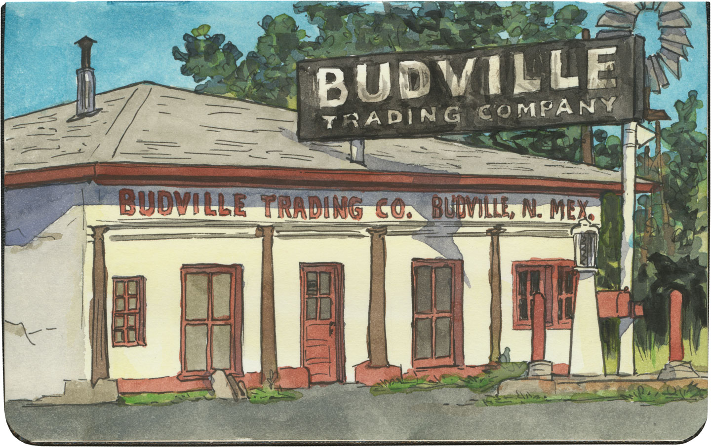
One of the grandest Route 66 traditions is the souvenir shop—or as it is more frequently named here, the trading post. And few Mother Road icons have such a long history. Starting as supply hubs and early post offices for fur traders, wagon trains, survey expeditions, gold prospectors and the like, trading posts were bastions of commerce and news in remote places.

The contemporary version of the trading post has sprung out of twentieth-century myths of the Old West: modern tourists wanted to experience a slice of the Pony Express, or send postcards from Boot Hill, or bring home a piece of Navajo jewelry—in air-conditioned comfort, of course.

Route 66 sketch by Chandler O'Leary

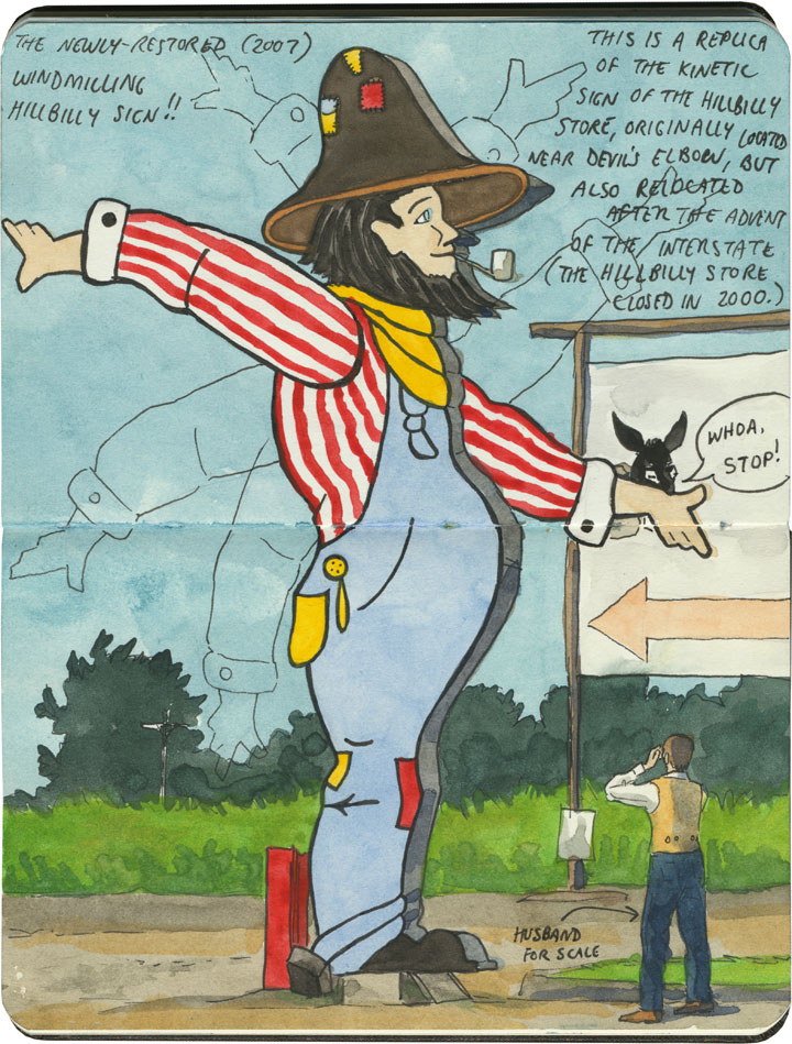
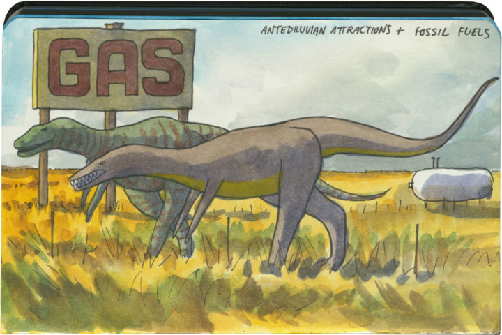
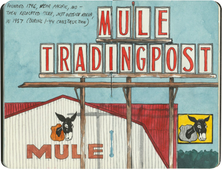
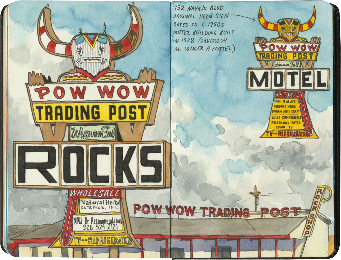
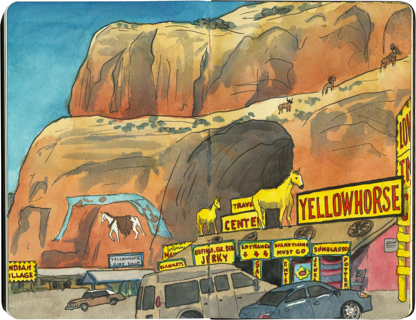
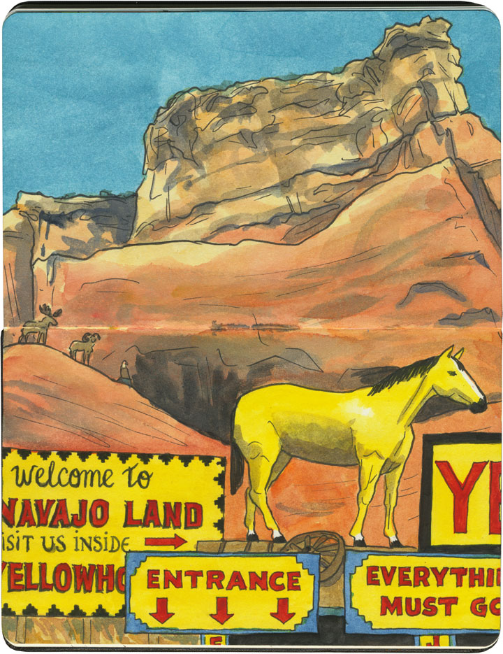
And nobody has cashed in on trading posts quite like Route 66: the Jackrabbit, the Continental Divide, Tee Pee Curios, the list goes on. On the Mother Road, the term “trading post” has become synonymous with “tourist trap”—many of these places combine commerce, entertainment and the flavor of the Wild West (or in the case above, the Hillbilly Ozarks). Far beyond a simple pit stop or junk store, some have more in common with theme parks.

Route 66 sketch by Chandler O'Leary

And while some have their roots in the actual Old West, many of these pit stops were built after Route 66 was run through. (Subsequently, in places where the modern Interstate diverted traffic away from 66, many of these trading posts are crumbling or closed altogether.)

Route 66 sketch by Chandler O'Leary

Thanks to historical examples like Hudson’s Bay Company, or the Hubbell Trading Post on the Navajo Nation, which has operated on the pawn (barter) system since the 1870s, we tend to associate trading posts with Indian Country. Route 66 is a prime example: half of the route (over 1300 miles) crosses through Native America, connecting more than 25 Indigenous nations. And since the vast majority of the Mother Road’s trading posts (and nearly all of those west of the Texas-New Mexico line) deal in Native goods, it’s no wonder a road trip through the Southwest makes us think of kachinas and beadwork.

Route 66 sketch by Chandler O'Leary

Though many of these shops are run by white owners, some are owned and operated by tribal members themselves.

Route 66 sketch by Chandler O'Leary

Regardless of who owns them, the overall effect of these places can run the gamut between eye-frying…

Route 66 sketch by Chandler O'Leary

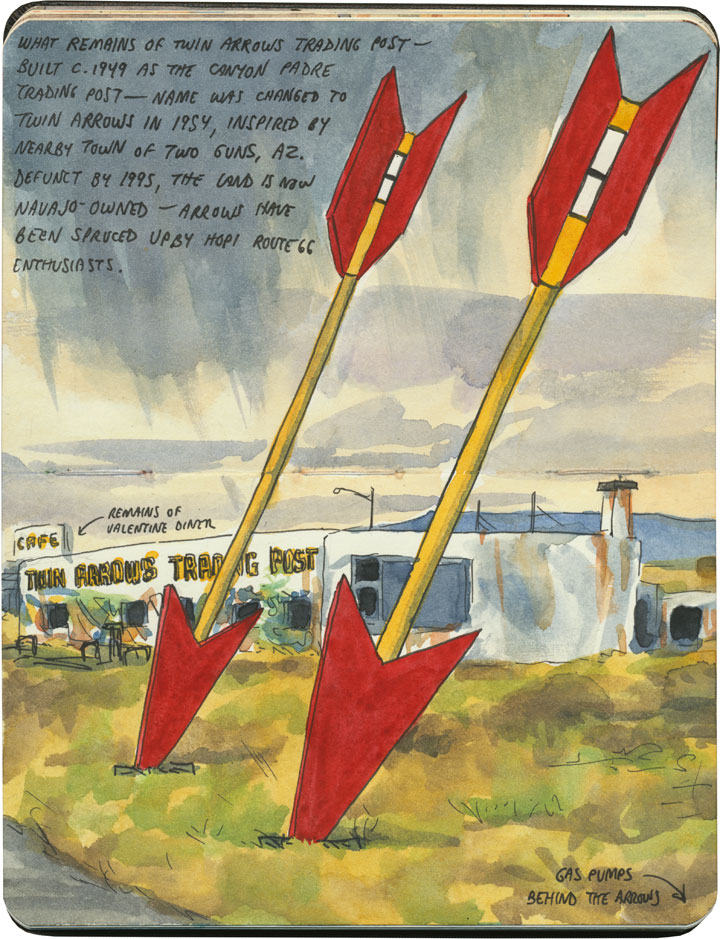
…and downright melancholy.

Route 66 sketch by Chandler O'Leary

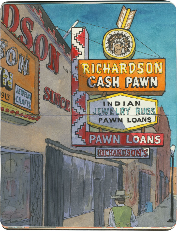
Gallup, New Mexico, has a little of both. Known as the “capital” of Indian Country, the town of 20,000 or so is the gateway to many American Indian nations, home to nearly a quarter of a million Indigenous people. As a result, Gallup is chock-a-block with trading posts and pawn shops, where local Navajo, Hopi, Zuni and others pawn their jewelry and other handmade goods in exchange for cash, staples or dry goods—and the shop owners then sell the jewelry to tourists. Nearly all of these shops are run either by white or, increasingly, Middle-Eastern owners.

Route 66 sketch by Chandler O'Leary

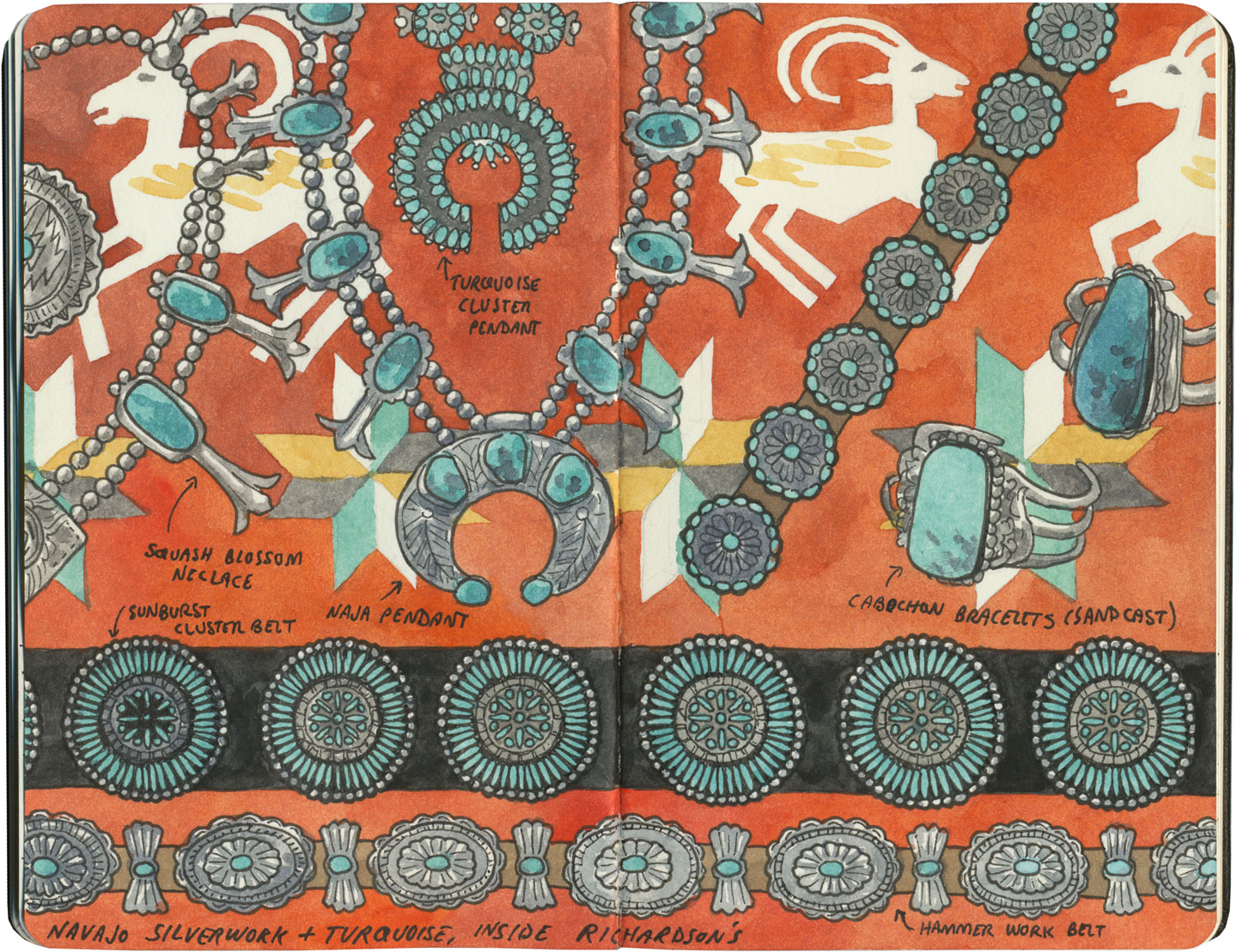
Gallup’s pawn shops have a controversial history, with some establishments accused of dealing in fake goods or cheating Indigenous makers out of a fair price for their work. So I did a little homework before we arrived, and chose Richardson’s as the place we’d visit. The shop has been in operation for over a hundred years, and though the Richardson family is white, they have a long reputation of being reputable dealers with a good relationship with the nations it represents. We marveled at the beauty on display there—some of the jewelry were incredible “old pawn” antique pieces.

Santa Fe sketch by Chandler O'Leary

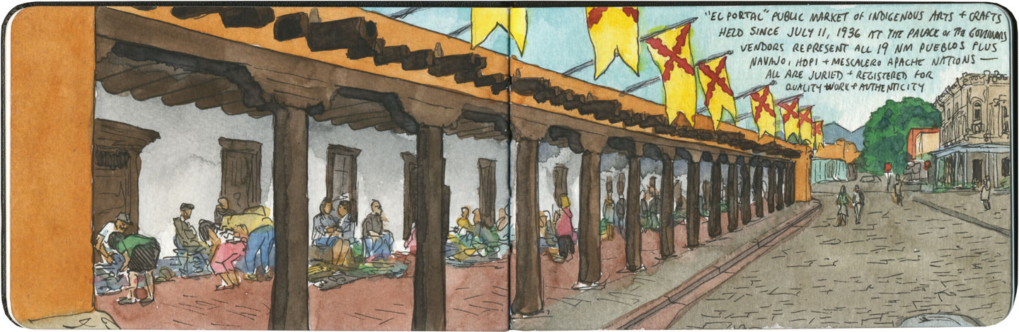
Still, my favorite trading experience on our Route 66 trip was when we had the chance to buy goods directly from the makers. In Santa Fe we shopped at the famous market at the Palace of the Governors, where artisans representing all of the region’s Indigenous cultures sell handmade jewelry, pottery, textiles, etc. at fair-trade prices. Each artist has to apply to the Native American Vendors Program to be included in the market, and the museum at the Palace of the Governors monitors each vendor to make sure the goods are authentic and the prices fair to the makers. (And bonus for history nerds like me: it’s really something to know you’re standing in the oldest continually-occupied public building in the country while you’re at it.)

Santa Fe sketch by Chandler O'Leary

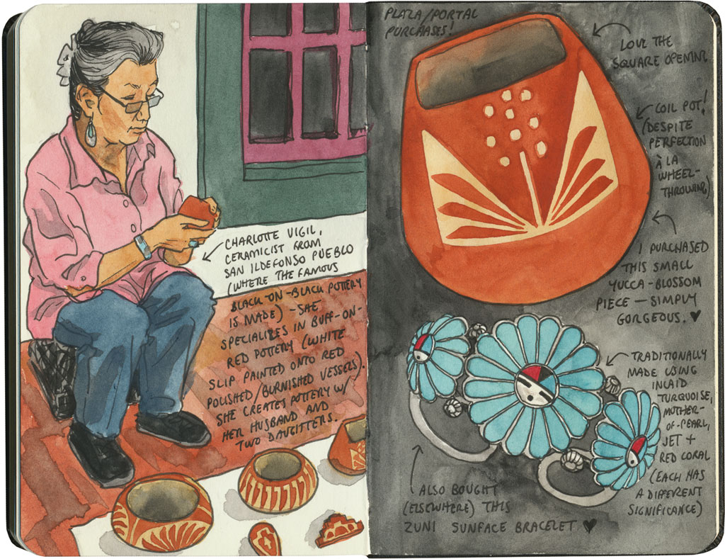
In the end, I could only afford a couple of small items, but I was happy to know I was paying what they were actually worth (I don’t haggle, especially not with fellow artists), and that the proceeds would go directly to the maker. And best of all, I got to hear the stories behind each piece, from the person who made it.

That seems like a fair trade to me.

Save

Route 66 sketch by Chandler O'Leary

Extinct but very much alive

This post is part of an ongoing series called 66 Fridays, which explores the wonders of old Route 66. Click on the preceding “66 Fridays” link to view all posts in the series, or visit the initial overview post here.

Unlike the Columbia River Gorge and the Oregon Coast, the section of Route 66 that crosses eastern Arizona is actually a place known to contain real, no-kidding dinosaur fossils. (And unique ones, to boot: there’s a large concentration of Triassic-era early dinosaur species here.)

Route 66 sketch by Chandler O'Leary

Unsurprisingly, the Mother Road in that part of the state is positively crowded with roadside attractions that fill the dinosaur niche—most of them centered around the town of Holbrook. No matter what kind of concrete dinosaur you’re into, Holbrook has something for everyone. The prehistoric portrayals range from cartoony…

Route 66 sketch by Chandler O'Leary

…to surprisingly realistic…

Route 66 sketch by Chandler O'Leary

…to absurd…

Route 66 sketch by Chandler O'Leary

…to downright hilarous.

Amazingingly (and unlike many Route 66 landmarks), every dino-themed attraction here is still in business, still trapping tourists. May they live long and prosper—while they keep drawing crowds, I’ll keep drawing pictures.

Save

Save

Save

Route 66 sketch by Chandler O'Leary

The proof is in the pavement

This post is part of an ongoing series called 66 Fridays, which explores the wonders of old Route 66. Click on the preceding “66 Fridays” link to view all posts in the series, or visit the initial overview post here.

It’s easy to take for granted the fact that the American West is crisscrossed with highways nowadays, but those highways didn’t get there by chance. If you look closely at the routes those highways take, you can give yourself an excellent crash course in history, both human and natural. Overland exploration, trade routes, desert basins, animal migration, continental drift…all these things and more are hinted at by the map sketched out by the U.S. highway system.

Let me explain what I mean. If you happened to grow up in the Midwest, chances are your mental map would be dictated by a grid that follows the cardinal directions. In the Great Plains, particularly, where the landscape is mostly flat, dividing property lines and town borders into a standard grid makes the most sense. Much of the United States west of the Appalachians is arranged this way, in fact, in a basic grid called the Range and Township system. The system overlays a simple framework of one-square-mile sections over the entire western two-thirds of the country, dividing the landscape into rangeland for farming and six-mile by six-mile townships. Interestingly enough, we have Thomas Jefferson to thank for this system, which he devised in 1785 as a way to manage the vast swaths of land that, after the Revolution (and some years later the Louisiana Purchase), now belonged to the U.S. His reasoning, I think, was both practical and lofty: as a farmer himself, he was looking for a workable alternative to the inherited system of Metes and Bounds, England’s age-old framework for managing farmland and water access. While that system worked for the colonies, each roughly comparable in size and topography to what they knew in the Old World, the old framework wasn’t scalable to the size of the new West—particularly when tracts of land were being sold off sight-unseen to settlers and prospectors. But beyond the practical logic, I think Jefferson had more philosophical motives behind his plan. This is the guy who designed Monticello, after all, a monument to neoclassical thinking and an homage to ancient Greece and Rome. The Range and Township system applied a sense of order—however illusory—to the uncharted wilds of the West. It brought rational thought and a sense of opportunity to an area associated with chaos and the fear of the unknown.

Route 66 sketch by Chandler O'Leary

If you’ve ever visited the Great Plains, you can still see Thomas Jefferson’s plan in evidence, from the straight-as-an-arrow farm roads in rural areas, to the faithful system of thoroughfares in cities like Tulsa or Dallas, where the roads always travel from A to B in a straight line, with traffic lights appearing like clockwork at precise one-mile increments, and tenth-of-a-mile residential blocks in between.

But here’s the problem: Thomas Jefferson never laid eyes on the West he gridded out like a piece of paper. He never saw nature’s rebuttal to rationality in the Rockies or the Colorado Plateau. It’s all well and good to have a sensible grid in a flat place, without major physical features to interrupt the plan. But in many parts of the West, Jefferson’s tidy squares becomes utterly useless. You can’t easily farm a quadrangle of land that’s bisected by a canyon, and you can’t run a road up and over a mountain. Travel in a straight line is impossible in many, many places. As everyone from Chief Joseph to Lewis and Clark to highway engineers could tell you, there are some places in the West where only one route overland is possible—or none at all.

Route 66 sketch by Chandler O'Leary

So if you look at a modern highway map of the western half of the United States, the limitations geography places on rationality are obvious. You can see precisely where the Corps of Discovery found their way to the Pacific Northwest, or where the stagecoaches hauled goods to Santa Fe, or how the Mormon pioneers tumbled out of the mountains to the Great Salt Lake, or the supply route linking the California Missions to Mexico. It’s all there, because centuries later we’re still traveling the exact same routes that humans always have, dodging mountains and following water to whatever their destinations were. The Conestoga wagons followed the game trails and trade routes of the various Indigenous peoples. The railroad followed the pioneers’ wagon tracks. The first pavement slabs paralleled the railroad grade, and modern Interstate freeways zoom right over many of those original roadbeds and trailways. Even the technology of conveyance was based on the older methods of travel—just look at the wheel base on a modern car, whose width matches that of railroad cars, themselves directly descended from the lineage of horse-drawn wagon measurements.

As you can probably guess by my long-winded introduction here, this stuff ties square in with Route 66 and the path it cuts to the Pacific.

Route 66 sketch by Chandler O'Leary

There are many places along Route 66 where you can see this progression of transportation history unfold before your very eyes. In flat places like central Illinois or eastern Oklahoma, there was no reason to reuse the same roadbed over and over again—they had all the land in the world at their disposal, and nothing to impede their path. So they simply built the new road alongside the old—over and over again.

Route 66 sketch by Chandler O'Leary

The result is a network of parallel lines, each wider than the last, each laid down at a different point in recent history. In these places, the land acts like a palimpsest, marked over and over again with new traceries of roadbeds, while the old ones, though crumbling in disrepair, still remain visible.

Route 66 sketch by Chandler O'Leary

Since Route 66 was decommissioned as an official national highway, there are places where it’s difficult to discern the original route. The old roadbed might be there, but the Mother Road can get lost amid a modern tangle of frontage roads, diversions, and replaced pavement.

Route 66 sketch by Chandler O'Leary

Part of the joy of traveling Route 66 is learning to recognize the old road. In some places, the path is lit up like a beacon with painted pavement and restored waymarking…

Route 66 sketch by Chandler O'Leary

…in others, tracing the original marks on the palimpsest becomes something of a quest.

Route 66 sketch by Chandler O'Leary

And then there are the places where the original pavement itself becomes the attraction along the way—like this gorgeous stretch of brick roadway in Illinois, paid for in the 1930s by a brick magnate and lovingly maintained as a curious relic of the past.

Route 66 sketch by Chandler O'Leary

My favorite of all was the long section of 66 that traverses central Oklahoma: the combination of good craftsmanship and a remote locale has preserved the original roadbed impeccably. It sounds nerdy to say it out loud, but I dare any 66 enthusiast not to feel a thrill when seeing that curbed Portland cement.

Route 66 sketch by Chandler O'Leary

By the end of our journey, we’d gotten really good at spotting the difference between old and new along the way. And whenever we lost the thread of the route (easily done, since there are so many alignments, many of which have been replaced or buried under modern roads), it became easier and easier to spot the hints that would lead us back to the Mother Road.

Route 66 sketch by Chandler O'Leary

What led me to travel Route 66 was a love of history and Americana, and a desire to travel a well-worn and well-loved path. I had no idea that it would be so much more—and something much closer to the feeling of solving a mystery. Beyond the fun of diners and neon, there’s a richer, subtler 66 to be discovered, if you’re willing to look a little deeper. All the clues are there—some of them stamped right into the pavement underfoot.

Save

Save

Save

Save

Save

Save

Save

Save

Save