Tag Archives: Texas

Route 66 sketch by Chandler O'Leary

Somewhere to lean on

This post is part of an ongoing series called 66 Fridays, which explores the wonders of old Route 66. Click on the preceding “66 Fridays” link to view all posts in the series, or visit the initial overview post here.

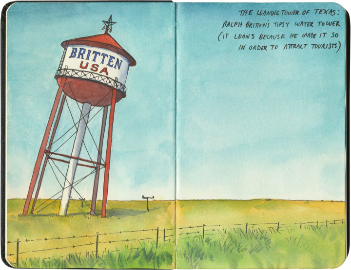
I crossed Texas twice last year: once at its widest point (where we logged over 900 Texas miles), and once across the Panhandle, which is where Route 66 cuts a literal straight and narrow path. One of the main Mother Road attractions to visit there is the “Leaning Tower of Texas,” a ho-made gravitational wonder in the middle of the neverending plain.

At least, it used to be in the middle of nowhere. Now it’s surrounded on three sides by other nearby giants: a bunch of those enormous modern windmills, and an awful 19-story cross that isn’t so much delightfully hokey as disgustingly hideous.

So I flashed my laminated Artistic License, faced east as to miss most of the horizon clutter, and edited out the rest. I regret nothing.

Llano Estacado sketch by Chandler O'Leary

After all, I was trying to capture the feeling of what it’s like to cross the Llano Estacado. Even today, when travelers have better navigational aids than makeshift stakes, it’s not hard to imagine how those first visitors must have felt.

Route 66 sketch by Chandler O'Leary

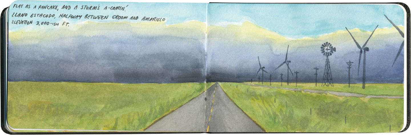
Or maybe modern technology has a different meaning here. Maybe the fenceposts and telephone poles and windmills that dot the landscape now are this era’s stakes, marching in steady progress across an otherwise unknowable vastness.

Pt. Bolivar Lighthouse sketch by Chandler O'Leary

Sunset sentinel

When Mary-Alice and I drove across Texas together last year, we knew our stop for this night would be somewhere around Houston. Neither of us fancied slogging through an enormous, unfamiliar city at rush hour, so from the passenger seat I pulled out the map to see if I couldn’t find an alternative. What I found was a lonely road that hugged the Gulf coast, then ended in a ferry to Galveston. Sold. (Also, as it turned out, best idea ever. That road was gorgeous!) Since we made the decision on the fly, I had no idea what we might find en route. So rounding a curve to encouter a 180-foot lighthouse looming suddenly above us in the purple dusk was not just an arresting sight—it was unforgettable.

Road trip map sketch by Chandler O'Leary

The final tally

If you happen to follow along on Instagram or Facebook, you’ll know I’ve just returned from a 4000+ mile road trip across the south and west of the county. One of the things I like to do at the end of a trip (and the end of my sketchbook) is a map and recap of the journey. Of course, there are lots and lots of sketches of the details along the way (I expect you’ll see lots of those in the coming weeks), but sometimes it’s nice to step back and look at the big picture.

Owl sketch by Chandler O'Leary

Bird- and beastwatching

Whenever I travel closer to home, where the flora and fauna are familiar to me, my birdwatching sketches look a lot like any other in my sketchbooks: full scenes, with plenty of time taken to get the details right. (And if my subject should happen to wander away—well, if it’s something I’ve seen before, memory can usually fill in the rest.)

Big Bend National Park wildlife sketches by Chandler O'Leary

When I was at Big Bend, however, the combination of excitingly “exotic” wildlife and an insane amount of it made my drawings just a jumble of frantic chicken scratches and field notes.

Big Bend National Park wildlife sketches by Chandler O'Leary

I felt like a student in art school again, concentrating hard to commit my subjects to paper in just a few seconds, drawing and redrawing everything again and again to try to nail down anatomy and details in real time.

Big Bend National Park wildlife sketches by Chandler O'Leary

As you can probably guess, I like having more time to “finish” a sketch… but I also love that life drawing in a place where I don’t know bupkis keeps me on my toes.

Rio Grande River Road sketch by Chandler O'Leary

The road less traveled

Since I’ve got a road theme going this week, I thought I’d spend the next couple of posts highlighting some of my very favorite squiggly lines on the map. Everyone seems to have California Highway One at the top of their road trip bucket list (for good reason!), but FM170 in West Texas deserves to be on that list, as well.

Rio Grande River Road sketch by Chandler O'Leary

The River Road isn’t nearly as well-known as the Pacific Highway because it’s in the absolute back of beyond. Whoever coined the term “middle of nowhere” probably had this place in mind—but as it’s right near a national park, it probably also escapes the notice of tourists wanting to take the faster state highway to and from the park.

Rio Grande River Road sketch by Chandler O'Leary

And that’s a shame, because this road is a gem. It winds right alongside the Rio Grande, through the Santa Elena and Colorado canyons, passing ghost towns and old Spanish missions along the way. In the 70-mile section we traveled that day, we only saw one other soul—and that was a local immigration cop parked along the roadside. We didn’t pass a single tourist along the way.

Rio Grande River Road sketch by Chandler O'Leary

I would have loved to drive this road (I have a thing for taking mountain curves with a stick shift!), but I wanted to spend the time drawing. So the Tailor, bless him, tackled the hair-raising turns, and didn’t bat an eye when I made him pull over about a hundred times for spectacular vistas.

Rio Grande River Road sketch by Chandler O'Leary

I can’t recommend this road enough. If you go, though, make sure you have plenty of drinking water, engine coolant, gasoline, and a fresh spare tire, just in case. If you break down, you’re going to need the tools and skills to get yourself back out again—this is the type of route that laughs at puny human concepts like mobile phone coverage (pro tip: there isn’t any) or roadside assistance. This is the kind of place that analog map freaks like me are talking about when we say GPS ain’t all it’s cracked up to be.

Rio Grande River Road sketch by Chandler O'Leary

But if you’ve got a paper map and a good sense of adventure, hit the road: because this is the place.

Save

Marfa, Texas sketch by Chandler O'Leary

The “steer” in steering wheel

If I saw this big boat sailing through Seattle rush hour traffic, it would completely make my day—gridlock or no. I guess it’s sort of a moot point for me, since I work from home, but if I had any sort of morning commute at all, I could totally see myself rockin’ it with this baby.

Camping sketch by Chandler O'Leary

Pet sounds

The Tailor and I bought two new pairs of binoculars for our trip to Big Bend last year, because we knew we could expect to do some serious birdwatching there. What we didn’t find out until the ungodly hours of our first morning in the tent: the birdlistening was every bit as intense.

Sky islands sketch by Chandler O'Leary

Island in the sky

I’ve talked before about being on Island Time—and in a weird way, this is kind of the same thing. You see, islands don’t just exist in water; you can find them in the middle of the desert, too.

The Chisos Mountains, in the heart of Big Bend National Park, rise 4,000 feet above the parched desert floor below. The elevation gain gives them a dramatically different climate than their surroundings. The name they call these types of mountains just melts my heart: sky islands.

I don’t know about you, but that reminds me of the sort of things I used to dream up when I was a kid. Of Shangri-la and castles in the air. Of quests and secrets. Of dirigibles and airships.

Who says park rangers aren’t romantics?

Big Bend cactus sketches by Chandler O'Leary

Ka-bloom

The Tailor and I visited Big Bend in mid-April, our best chance to catch the cacti in bloom. When we got there, a park ranger warned us not to get our hopes up. He told us they’d been experiencing a record drought—the park had only received about three inches of rain, total, over the past two years.

And then, that night, the wind picked up and the skies opened.

It absolutely poured on our tiny two-man tent (which miraculously stayed dry). Half an inch in four hours. Now, if you live in a naturally stormy place, you’re probably thinking, “That’s nothing!” But in the Chihuahuan Desert, after a prolonged drought, that storm gave us just cause to worry about washed-out roads and flash flooding.

The next morning, we thought our best reward might be cooler temperatures—until we went on a hike, and discovered what was waiting for us:

Big Bend cacti sketch by Chandler O'Leary

These guys wasted absolutely no time. Nearly every plant in the park went from zero to peak bloom in just a few short hours. I have never seen anything like it.

That day the phrase “painted desert” had a whole new meaning.

Big Bend cacti sketch by Chandler O'Leary