Tag Archives: Pacific Northwest

Covered bridge sketch by Chandler O'Leary

New England transplant

You wouldn’t normally think of the Pacific Northwest as covered bridge country, but we do have a few here. Southern Oregon is home to a real beauty, and the last covered bridge still standing along old Highway 99. Of course, the rainy Northwest weather and towering conifers gave it away, but otherwise, the place made me feel like I was standing in a Vermont mountain glen.

Poulsbo, WA sketch by Chandler O'Leary

Vort daglige brød

Like the town of Solvang in California, there’s a Scandinavian town in my neck of the woods, too. Except in contrast to Solvang, I love Poulsbo. Even though it’s a bit of a tourist trap, Poulsbo feels more humble, more down-home, more real. Its Norwegian roots run deep—I have even heard Norwegian spoken on the street there.

The best part of Poulsbo is Sluy’s Bakery. The place isn’t strictly Norwegian (you’ll find German and American treats there, too), but they know their Scandinavian pastries and have plenty of Norwegian delights to choose from. And while I don’t have any Norwegian ancestry myself, I didn’t live in both Minnesota and North Dakota for nothing. So Sluy’s has become a regular stop for me whenever I find myself on that side of the Sound and need a lefse fix.

Poulsbo, WA sketch by Chandler O'Leary

Since today is St. Olaf’s Day in Norway, I figured that might be a good excuse to go out in search of a little eplekake.

Seattle Viaduct sketch by Chandler O'Leary

The road overhead

We got stuck in some serious traffic on our way to the game yesterday, which had me wishing we had taken the Viaduct into town instead. That made me remember this sketch I did a couple of summers ago—one of several I’ve done over the years, knowing full well that the Viaduct’s days are numbered.

The Viaduct is an elevated section of Highway 99 that flows into downtown Seattle along the waterfront. It’s been the focus of controversy for years (crumbling infrastructure, real estate and tax feuds, voter indecision, construction fiascos, indefinite timelines, etc.), but whatever your opinion of it might be, it’s unquestionably a city icon. Personally, I’ll miss the experience of coming into the city by the Viaduct, with its spectacular views of the skyline and the Sound. And I already miss my trusty network of shortcuts, now blocked by the construction zone and the already partially-demolished highway. But whatever is coming, and whenever it does, I plan to have plenty of sketches under my belt by which to remember it.

Seattle Mariners game sketch by Chandler O'Leary

On the ball

Today the Tailor and I had the chance to go to a Mariners game with friends, and spend the afternoon in the cushy comfort of one of the box suites. In terms of watching the game, it was the best seat in the house. We were in the front row of the box, with a breathtaking view of home plate—we could practically call the strikes. But when it came to sketching the game, it made me downright twitchy. It seemed like every time I took my eyes off the game to look down at my drawing, a batter would whack a foul ball in our direction. At least four or five came within spitting distance, and there was one that almost startled me into dropping my sketchbook over the balcony railing. By the fifth inning, though, I had the routine down: scribble quickly between pitches, and every time you hear a crack, look up and find that ball fast!

Fourth of July sketch by Chandler O'Leary

Fire up the grill

We have a tradition of spending the Fourth with some friends who live down the street from us. We bring the old-fashioned hand-crank ice cream crock and the croquet set—they fire up the grill.

Fourth of July sketch by Chandler O'Leary

The best part, though, is watching the fireworks over the bay.

To everybody reading in the United States, have a happy and safe Fourth of July!

Ladd's Addition map sketch by Chandler O'Leary

Residential roses

June is the month of roses in the Pacific Northwest, and there’s no better place to see roses than the City of Roses. And there’s no better rose garden in the City of Roses than the diamond gardens in Ladd’s Addition. So in honor of my favorite Portland neighborhood, here are two midsummer sketches, done exactly three years apart.

Ladd’s Addition was the first planned residential development in the state of Oregon. Conceived in 1891 and mostly built between 1905 and 1930, the area is now a national historic district. In deliberate contravention of the city grid, the neighborhood is laid out in an “X” pattern with a circle park and rotary in the center. Where each diagonal street intersects one other at points north, south, east and west of the circle, there’s a small diamond-shaped garden that’s home to one of Portland’s many rose test gardens. And along every tree-lined and tree-named (though some have been rechristened in modern times; the map above shows their original names) street are many dozens of historic homes—many of which are unique or unusual examples of Craftsman-, Tudor- and Mission-style architecture.

Ladd's Addition rose garden sketch by Chandler O'Leary

Every part of this neighborhood is appealing to me—I’m a sucker for a good map, a Craftsman house and a pale peach rose. Put them all together, with a shady spot for me to sit and sketch, and I’m instantly in heaven.

Aerial sketch by Chandler O'Leary

Bird’s eye view

Like I said the other day, point-of-view is everything. And while flying isn’t my favorite way to travel, I absolutely love it when the weather is clear enough that I can see the landscape below. I love being able to draw the scene below like a map, and—especially in places I know well—follow along with the changing scenery, like reading a living atlas.

Orcas Island sketch by Chandler O'Leary

Porch perch

Sometimes one’s point of view can make or break a picture. The jury is still out on this one, as far as I’m concerned. This was such a weird vantage point for sketching—between the location high up on a hill, the wide-angle view of the rest of the porch, the water and ferry landing below, and the islands off in the distance, everything was just…odd. Unsettling. I spent a long time on this one, using every art-school trick I knew to check and re-check that my perspective was correct. It was…for the most part. But the drawing still feels like something M.C. Escher would have come up with.

Chambers Bay golf course sketch by Chandler O'Leary

Hole in one

Since I was thinking about examples of American ruins at the time, my plan was to head across town to sketch the remains of the old sand and gravel quarry at the site of the Chambers Bay golf course. But when I got there, the trail that leads to the ruins was closed while they set up for this year’s U.S. Open golf tournament.

I’m no expert on golf, but it’s been fun to learn more about the Chambers Bay course in the run-up to the event. The course is both public and brand new—just eight years old—which makes it an unusual choice for the U.S. Open. But it’s an absolute marvel of design and difficulty. Chambers Bay is many times larger than a traditional Scottish links-style course; the combination of sheer size, rugged terrain, tricky fescue-and-heather landscaping, and the strong winds that sweep through the Tacoma Narrows make this course one of the most challenging and unpredictable in the entire world. Add to that the stunning panoramic views of Puget Sound and the islands, and it’s no wonder the USGA thought the world would want to feast their eyes on Chambers Bay.

The tournament opens on Monday, and thanks to the expensive tickets and the maelstrom of golfers, spectators, media and security descending upon my town, the likes of me won’t be able to get anywhere near Chambers Bay. But that’s okay—I got to have a front row seat for the transformation. When it’s all over, there won’t be any ruins left behind to commemorate the event—there won’t be any trace left at all. All the more reason to have the evidence recorded in my sketchbook.

Old Clatsop County Jail sketch by Chandler O'Leary

Goonie weekend

I’m a bit of a movie nut—especially for anything shot on location. I’m a sucker for films that center around real places—and Astoria, OR has featured prominently in so many movies that the entire town has become a cinema icon. This Sunday marks the 30th anniversary of the release of the 1980s free-range-kid classic, The Goonies, so I thought I’d celebrate by posting my Goonie sketches from a few years ago.

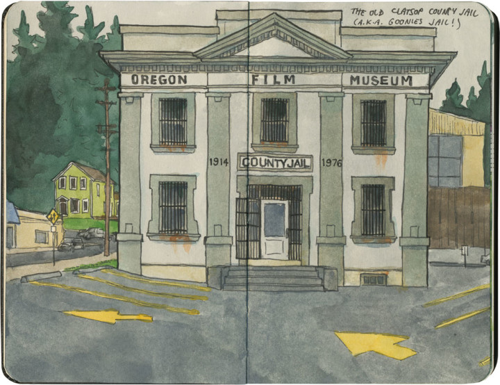
First up is the most well-known location in town, and the one that’s easiest to find: the old Clatsop County Jail from the hilarious jailbreak scene. This building is so iconic that it’s now home to a museum centered around the movies filmed in Oregon.

Goonies house sketch by Chandler O'Leary

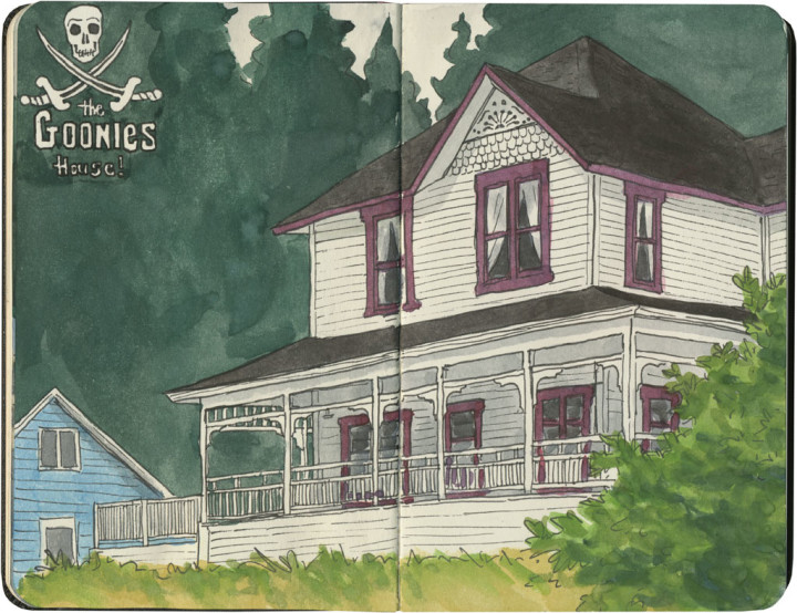
Next up is Mikey and Brand’s house (with a glimpse of Data’s place next door). This house looks almost exactly the same as it does in the film—at least from what I could see below. I have a feeling the current owners put up with a lot of well-meaning trespassing from Goonies fans, so I wanted to be respectful of their property and stay on the sidewalk below. Oh, and incidentally, this house is literally around the corner from the school featured prominently in Kindergarten Cop (yes, I’ve sketched that, too—that’s a post for another day).

Cannon Beach sketch by Chandler O'Leary

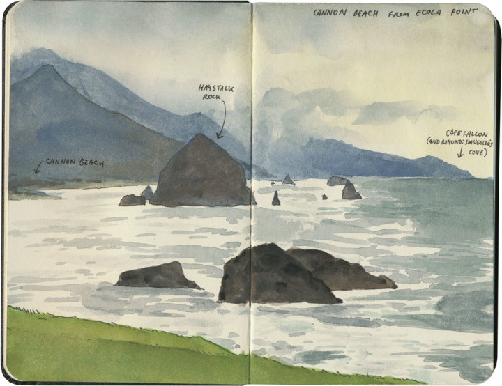
Finally, no Goonies pilgrimage would be complete without a side trip to Ecola State Park, about a half hour south of Astoria. This is the spot where the gangster hideout was, where the kids entered the underground path to pirate treasure. From here you can spy (through the holes in a 1632 Spanish doubloon, of course) Cannon Beach below, and the silhouetted bulk of Haystack Rock—which you might recognize as the seastack that looms above the final scenes in the film.

This weekend Astoria is having a big 30th anniversary celebration, but I won’t be able to get down there for the event. So instead, you can bet the Tailor and I are going to pop up some popcorn, fire up the DVD player, and have ourselves a blast from the past.