Tag Archives: islands

Channel Islands National Park sketch by Chandler O'Leary

Land’s end

Speaking of sunny SoCal islands, on my last book research trip I finally got to cross a big line item off my national parks bucket list: Channel Islands National Park. I made this sketch at Inspiration Point (I really should do a post sometime about all the Inspiron Points in the various national parks…there are a bunch of them, and many of them have inspired me to sketch!) on Anacapa Island, and the finished drawing ended up being, in turn, the inspiration for one of the illustrations in my book.

Excerpt of "The Best Coast" book by Chandler O'Leary

These days I’m drawing a different kind of inspiration from my national parks sketches: inspiration for future return trips, when travel becomes a thing again. In the meantime, hoping you are safe and well, and finding inspiration in your own travel memories!

Catalina Island sketch by Chandler O'Leary

Island paradise

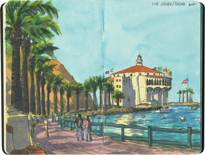
One of the things I’ve been doing in my little metaphorical lighthouse lately is dream of sunny shores and road trips past. And my favorite place to remember right now is Santa Catalina Island—26 miles off the coast of southern California—which I visited a few years ago while researching my book. The centerpiece of Avalon, the Catalina’s main town, is the Catalina Casino—which is not that kind of casino at all. The building is modeled after the Italian word meaning “gathering place.” Upstairs is a massive ballroom—the largest circular dance floor on earth. In the 1930s and ’40s, famous big-band musicians broadcast live performances here (which you’ll recognize if you’ve ever seen an old vinyl recording with “Live at the Avalon Ballroom” in the title). Hollywood stars made frequent appearances at these events, as Catalina was long a playground for movie stars from the 1920s until the 60s. Downstairs is the Avalon Theatre, the world’s first cinema ever to be wired for sound. (Its acoustically perfect design was copied at Radio City Music Hall in New York.)

Inside the theater and lining the entry portico are a series of breathtaking art deco murals by John Gabriel Beckman (who designed Grauman’s Chinese Theatre in Hollywood)—those deserve a post all their own, so for now, I’ll stick to the exterior. What I love most about this building is its sheer presence. Not only is it absolutely massive (twelve stories tall!), but its location at the tip of the half-moon harbor makes it the centerpiece of every Avalon view. It’s postcard-perfect in every way.

Postcard excerpt from "Greetings from the Best Coast" book of 32 postcards by Chandler O'Leary, published by Sasquatch Books

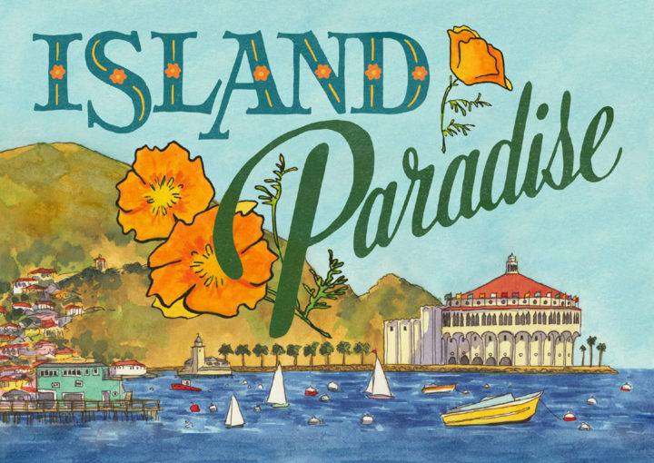
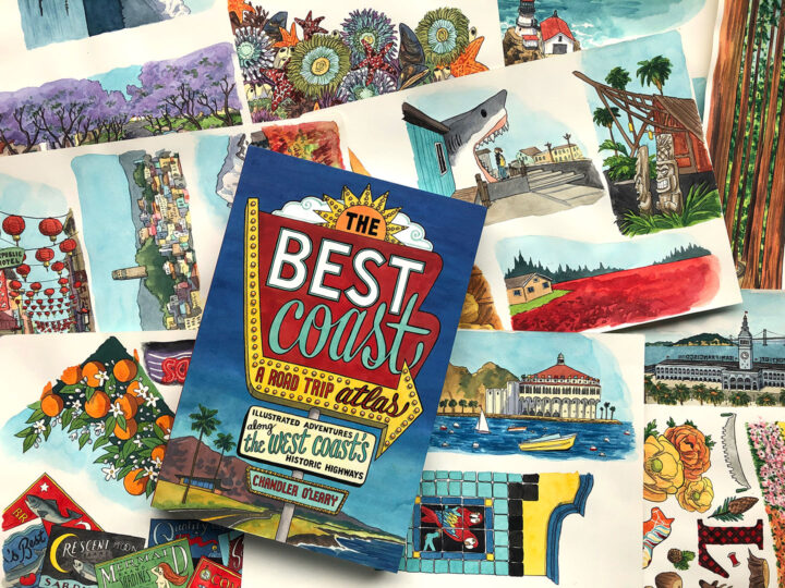
Which, by the way, is why I had to include it in my new postcard book. There are sixteen different postcard designs in the book, and more than 400 illustrations in my Best Coast book—so that made for quite a lot of hemming and hawing between myself, my editors, and the design team at Sasquatch Books over which images to turn into postcard. But not this one. Thanks to the casino, Catalina was a shoo-in—and quite possibly my favorite illustration in both books.

So I’m mailing copies of this card from my studio right now, but it’s my current dream to get back to Catalina sometime soon (when it’s safe to travel, of course), and mail it with a postmark from Avalon.

Book cover and process images from "The Best Coast" book written & illustrated by Chandler O'Leary, published by Sasquatch Books

Today’s the day!

Today is the “book birthday” of The Best Coast: A Road Trip Atlas! After nearly three years of work and a solid decade of research, I can’t believe this day is here. I am so excited to share this labor of love with you, and I hope you’ll love it, too. With 99 hand-drawn maps, more than 400 full-color illustrations, and several hundred more illustrated icons, vignettes, and hand-lettered type treatments, it’ll give you plenty to sink your teeth into for your next road trip!

I owe a boatload of thanks to Sasquatch Books for making this book both a reality and a thing of beauty—especially to Anna Goldstein and her design team, and my longtime editor, Hannah Elnan. And thanks also to the indie bookstores and West Coast museums, restaurants, travel boutiques and souvenir shops that have championed this book—thanks to them, I can say not only can you find it “wherever books are sold,” but in all sorts of wonderful places, all up and down the Best Coast!

Happy reading, and happy travels!

UPDATE, March 2020: You can now also find signed copies in my web shop!

San Juan Island sketch by Chandler O'Leary

Fox tales

Every time I visit San Juan Island, my collection of fox sketches grows. They’re inescapable there, as much a part of the landscape now as the treeless prairies they prowl at Cattle Point.

San Juan Island sketch by Chandler O'Leary

They’re not native to the island, though. In the 1890s, settlers introduced rabbits here for game, and apparently failed to foresee the obvious consequences. Of course, the rabbits did what rabbits do, and in the following decades island residents introduced red foxes to try to make a dent in the rabbit hordes. What has followed ever since is a population tug-of-war: some years the rabbits get out of control again, and the foxes have plenty to feast upon. Then the rabbits decline and the foxes get overpopulated and start dying off…the cycle repeats every few years or so.

San Juan Island sketch by Chandler O'Leary

For the past five years or so, I’m guessing the island’s been in a fox cycle, because I have yet to see a rabbit on my visits there (though Orcas and Whidbey Islands are both overrun). And unfortunately, tourists tend to feed the foxes, which doesn’t help matters. But whenever I feel like studying fox anatomy, all I have to do is head down to Cattle Point, pull over at a certain overlook, and wait. It never takes long for someone to show up to have their portrait painted.

Save

Save

San Juan Island sketch by Chandler O'Leary

Seaside splendor

You already know that San Juan Island is perhaps my favorite place on earth, and the California poppies that grow wild at Cattle Point are just one of the many reasons why. I actually started this sketch on an earlier trip, and came back to this spot exactly one year later to finish it. And it’s a good thing I did, because after the super-wet winter we had on the West Coast, I’ve never seen quite this many poppies in bloom before. After I finished the sketch, I just sat there on the hillside for another half hour or so, not wanting to break the spell of such a perfect moment.

Pelindaba Lavender Farm sketch by Chandler O'Leary

Purple haze

Here in the Northwest, we’re in the thick of my favorite season right now. I don’t mean summer, per se, but lavender season. Our climate is pretty much perfectly suited to growing lavender, so other than maybe the south of France, there’s no better place to stand on a purple hillside, awash in scent.

San Juan Island sketch by Chandler O'Leary

From a certain angle

Lime Kiln Point is one of Washington’s best state parks. For one thing, it’s on my favorite island (and since I love all of Washington’s islands with a mad passion, that’s saying something). For another, it’s got a great lighthouse—which is something for which I’ll always come running. Best of all, if you happen to be there at the right time of year, or are just insanely lucky, you’ll be treated to an extra surprise. Don’t see what I mean? Look again, closely, at the sketch, and you’ll get what I’m angling at…

Aerial sketch by Chandler O'Leary

Bird’s eye view

Like I said the other day, point-of-view is everything. And while flying isn’t my favorite way to travel, I absolutely love it when the weather is clear enough that I can see the landscape below. I love being able to draw the scene below like a map, and—especially in places I know well—follow along with the changing scenery, like reading a living atlas.

Orcas Island sketch by Chandler O'Leary

Porch perch

Sometimes one’s point of view can make or break a picture. The jury is still out on this one, as far as I’m concerned. This was such a weird vantage point for sketching—between the location high up on a hill, the wide-angle view of the rest of the porch, the water and ferry landing below, and the islands off in the distance, everything was just…odd. Unsettling. I spent a long time on this one, using every art-school trick I knew to check and re-check that my perspective was correct. It was…for the most part. But the drawing still feels like something M.C. Escher would have come up with.

Chambers Bay golf course sketch by Chandler O'Leary

Hole in one

Since I was thinking about examples of American ruins at the time, my plan was to head across town to sketch the remains of the old sand and gravel quarry at the site of the Chambers Bay golf course. But when I got there, the trail that leads to the ruins was closed while they set up for this year’s U.S. Open golf tournament.

I’m no expert on golf, but it’s been fun to learn more about the Chambers Bay course in the run-up to the event. The course is both public and brand new—just eight years old—which makes it an unusual choice for the U.S. Open. But it’s an absolute marvel of design and difficulty. Chambers Bay is many times larger than a traditional Scottish links-style course; the combination of sheer size, rugged terrain, tricky fescue-and-heather landscaping, and the strong winds that sweep through the Tacoma Narrows make this course one of the most challenging and unpredictable in the entire world. Add to that the stunning panoramic views of Puget Sound and the islands, and it’s no wonder the USGA thought the world would want to feast their eyes on Chambers Bay.

The tournament opens on Monday, and thanks to the expensive tickets and the maelstrom of golfers, spectators, media and security descending upon my town, the likes of me won’t be able to get anywhere near Chambers Bay. But that’s okay—I got to have a front row seat for the transformation. When it’s all over, there won’t be any ruins left behind to commemorate the event—there won’t be any trace left at all. All the more reason to have the evidence recorded in my sketchbook.