Tag Archives: mountains

Mission Nuestra Senora de la Soledad sketch by Chandler O'Leary

Lonely outpost

This is the thirteenth installment of my Mission Mondays series, exploring all 21 Spanish Missions along the California coast. You can read more about this series, and see a sketch map of all the missions, at this post.

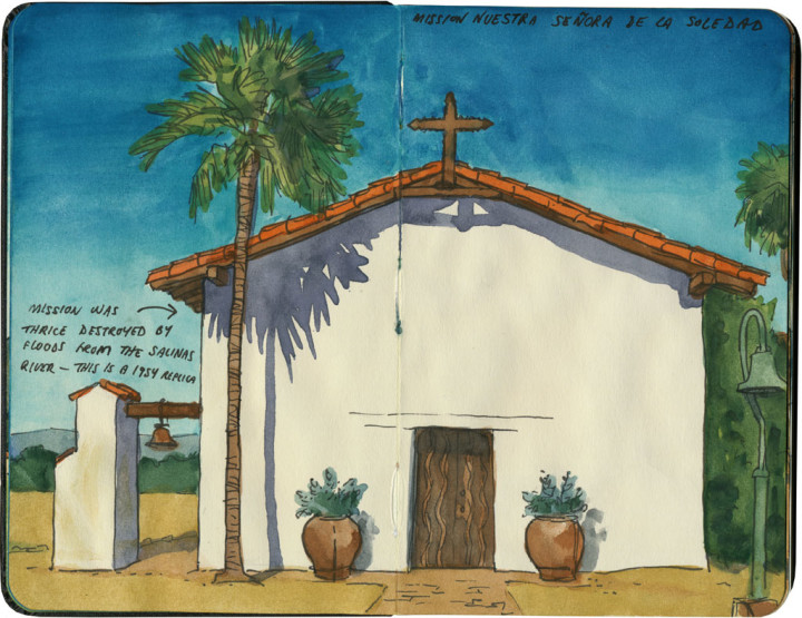
The “Soledad” in Mission Nuestra Señora de la Soledad means “solitude.” And boy howdy, is that ever accurate.

Detail of California Missions map sketch by Chandler O'Leary

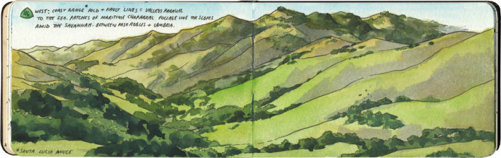
The third of three missions located in the Salinas Valley, La Soledad is also the most remote. It’s not as far off of modern Highway 101 as Mission San Antonio, but it’s the farthest from civilization.

Mission Nuestra Senora de la Soledad sketch by Chandler O'Leary

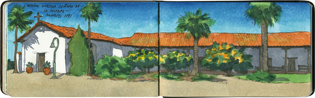
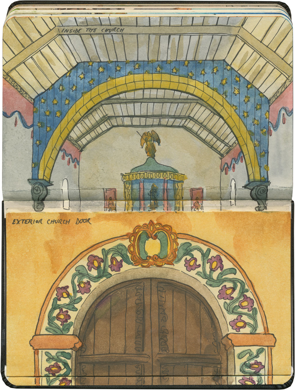
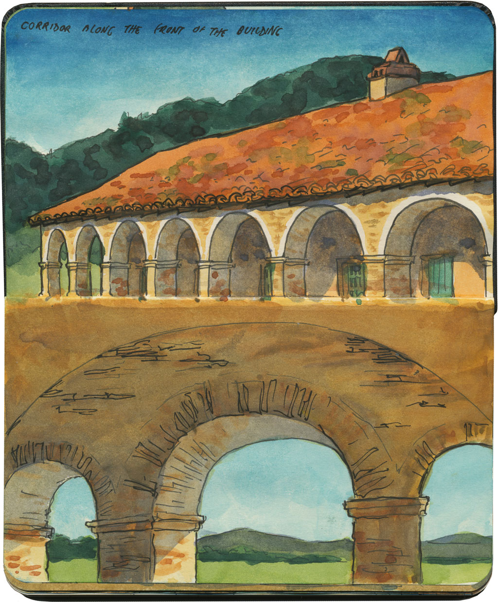
In fact, even though there’s almost nothing left of the original complex (thanks to the caprice of the Salinas River)…

Mission Nuestra Senora de la Soledad sketch by Chandler O'Leary

…you really get a sense for how self-sufficient the missions had to be when they were founded.

Mission Nuestra Senora de la Soledad sketch by Chandler O'Leary

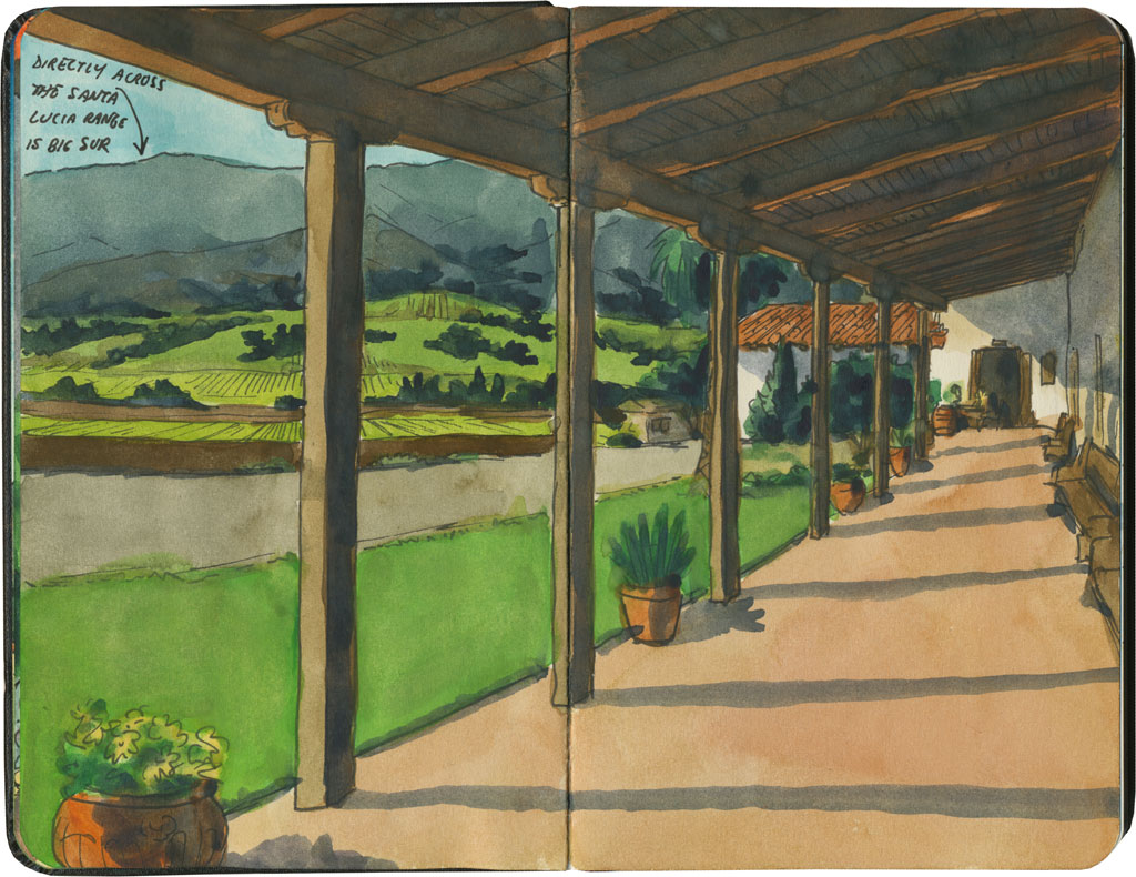
That’s because the mission is located smack in the middle of a bunch of vegetable fields. Quite literally. There’s no fanfare about the place—there’s barely even any waymarking to find it. It’s a bit of a shock, actually, after seeing mission after mission in town centers or near tourist traps.

But that’s the best part of the place: being able to stand in the shade and look out at a landscape right out of a Steinbeck novel.


Mission San Antonio de Padua sketch by Chandler O'Leary

Mountain mission

This is the twelfth installment of my Mission Mondays series, exploring all 21 Spanish Missions along the California coast. You can read more about this series, and see a sketch map of all the missions, at this post.

Note: At the time of my visit, the façade of the building was ensconced in scaffolding. I was so sad at the idea of including it in my sketches that I just…didn’t. I drew around it, and sketched as if it weren’t there. So know that if you go, you might not find it looking like this. I’m not sure how long the current restoration project will go on.

Today we’ll visit a mission that stands out among its brothers and sisters. While some details might bring to mind places like La Purisima or San Juan Capistrano, there’s simply nowhere quite like Mission San Antonio de Padua.

Detail of California Missions map sketch by Chandler O'Leary

As you head north out of San Luis Obispo along the Salinas Valley, you’ll pass three missions before you reach Monterey Bay. Each one is more remote than the one before, so make sure you have food, water and plenty of petrol if you decide to make the trek.

Mission San Antonio de Padua sketch by Chandler O'Leary

San Antonio, the second of the Salinas Valley three, is one of the oldest missions in the entire chain. And it has all kinds of features and details that you won’t find at any of the others—like the subtly contrasting archways. Or the campanile situated in front of the main entrance, instead of off to the side or around the corner.

Mission San Antonio de Padua sketch by Chandler O'Leary

The interior of the church is also really unusual, with its squared-off arches and wooden planking.

Mission San Antonio de Padua sketch by Chandler O'Leary

The overall look of the place is different, too—like this might be a Texas or New Mexico mission instead (or perhaps Italy, like San Antonio himself).

Mission San Antonio de Padua sketch by Chandler O'Leary

It’s certainly located in the most mountainous stretch of the Royal Road—and since you actually have to enter and cross a military installation (which buffers the place even further from modern civilization) to get here, the trip really feels like an old-fashioned expedition.

Maybe that’s what I liked best of all: this feeling of stepping back in time and seeing the one mission that is perhaps the closest to how it has always been.

Central Valley, CA sketch by Chandler O'Leary

Birdland

I’ve written about California’s Central Valley before, and I have a feeling it’ll come up again. But there are just so many things to love about the place. Perhaps the best part of all is the birdwatching.

Central Valley, CA sketch by Chandler O'Leary

The Central Valley is a main thoroughfare along the Pacific Flyway, and hosts thousands upon thousands of both migratory and native birds every year. The best time to birdwatch is in the late winter, when the valley is otherwise at its most drab. While most of the human tourists are in more “interesting” places like the coast, the avian tourists are literally flocking to the Inland Empire.

So while most folks might consider the valley to be a flyover region that’s beneath their notice, birders might just find it to be heaven on earth.

Palm Springs sketch by Chandler O'Leary

Desert welcome

Well, since I posted my sketch of “The Palm Springs of Washington” the other day, I think it’s only fitting to show you the Palm Springs of…uh, Palm Springs. I have to admit, I don’t like this welcome sign quite as much as the charming ho-made white lie in Yakima, WA, but I guess the real Palm Springs requires a gateway with a little more polish and panache.

I was chatting with someone who grew up in Yakima the other day, and these signs came up in conversation. He said, “Maybe one day Palm Springs will call itself ‘The Yakima of California!'”

It could happen, right? Well, I can at least picture what the sign would look like…

Mount Saint Helens sketch by Chandler O'Leary

Blown away

At precisely 8:32 am local time, 35 years ago today, Mount Saint Helens erupted. I wasn’t around for it—I wasn’t even quite born yet. But I’ve had a thing for volcanoes ever since I moved to the Northwest, so St. Helens has never been far off my radar.

The funny thing is, it’s taken me years to get a decent sketch of it.

I visited the St. Helens for the first time just weeks after I moved to Washington, when I got to tag along on a geology trip. I was all excited to sketch at the top of Johnston Ridge, to peer down into the massive crater. This is what I saw:

Mount Saint Helens (in fog) sketch by Chandler O'Leary

Yep, welcome to the Pacific Northwest.

After that it became sort of a running gag. I kept trying to find a time to get back to Johnston Ridge—but it’s a trip that takes commitment, since it’s a very long drive, it’s not on the way to anything, and the mountain roads are closed for much of the year. On every day that might have worked out for my schedule, the weather was bad or the way impassable.

Mount Saint Helens sketch by Chandler O'Leary

I did see St. Helens from a distance plenty of times, but even then it didn’t usually cooperate. More often than not, even on a bright sunny day, the volcano would be shrouded in its own private weather system.

So this year, I decided enough was enough. I cleared my calendar as best I could, and then just waited for a sunny day (at this time of year, one can wait a very long wait). Just a few days ago, the forecast offered up a perfect day—so I got up extra early and jumped in the car.

Mount Saint Helens sketch by Chandler O'Leary

This time, St. Helens rewarded my effort. And as a bonus, I got there a full week before the tourist season starts, so I had the mountain entirely to myself, for a whole morning.

It’s entirely possible the mountain will erupt again in my lifetime. I dearly hope it won’t…but at least I have some good “before” documentation, just in case.

Save

Mount Shasta sketch by Chandler O'Leary

Mountain mornings

I love coming back to a place I’ve already sketched, and giving it another go—I always end up with completely different results. These two drawings, for example, were done from precisely the same spot, almost exactly two years apart.

Mount Shasta sketch by Chandler O'Leary

Even though I’d been there before, and already spent a good amount of time studying the scene last time, I never seem to get bored on the return visit. Between changing weather, a different sketchbook, and whatever frame of mind I might be in that day, it always feels like I’m seeing the place with new eyes.

Garden of the Gods sketch by Chandler O'Leary

Garden notebook

On this morning I took a hike in a part of the world I know very well. Yet while the path was familiar, the rocks seemed to get more alien the more I stared at them. I kept trying different angles and colors, but I never did manage to nail down what I was looking at. I guess it’s sort of the visual-arts equivalent of proofreading: the more you concentrate on something, the more odd and unfamiliar it seems.

Big Sur sketch by Chandler O'Leary

Lone wanderer

I just got back from two and a half weeks of wandering in California—and by the time you read this, I’ll be on the road again, after just a few hours at home. The pre-trip scramble is never the most fun part of traveling, but I know that the trip ahead will have plenty of quiet moments like the one above.

California sketch by Chandler O'Leary

Folds and faults

If you were to page through my California sketchbooks, you’d think I had some serious A.D.D.—thematically they’re all over the place, because the state just has so many different things that interest me. But what I keep coming back to, time and time again, are the landscapes themselves. There is just something about the hills and valleys there that grabs hold of my heart and refuses to let go.

Columbia River Gorge sketch by Chandler O'Leary

Staycationland

What with moving into a new house and juggling a bunch of new studio projects this year, most of my sketching in 2014 was done pretty close to home. I have a feeling 2015 is going to be very different—several road trips are already on the calendar, and I’m making plans for others. Still, I’m glad I had this year to remind me that there’s so much to see in my own back yard.

So I’m raising a virtual toast this New Year’s Eve, to the distant road ahead—and to the garden path leading right back to my own door. There’ll always be room for both.

Cannon Beach sketch by Chandler O'Leary

Save