Tag Archives: 66 Fridays

Route 66 sketch by Chandler O'Leary

The tail wagging the dog

This post is part of an ongoing series called 66 Fridays, which explores the wonders of old Route 66. Click on the preceding “66 Fridays” link to view all posts in the series, or visit the initial overview post here.

Those of you who are fans of the show Breaking Bad will recognize Fido here, but you might not know that this beauty has graced Route 66 for over half a century. But while the place is notable both for its television fame and the fact that you can get red or green New Mexico chili sauce on your dog, I was there purely for the neon.

For almost all of our Route 66 trip, I had to content myself with seeing most of the Mother Road’s neon during daylight hours only. But luckily for me, we stayed with friends in Albuquerque that night. I told them I was dying to see the Dog House at night, so after dinner we all made the trek back down to Central Avenue together.

Route 66 sketch by Chandler O'Leary

I couldn’t decide which stage of the neon motion to sketch, so I drew them all. And that led me to an idea I’d never tried before…

Animated Route 66 sketch by Chandler O'Leary

…just a wee bit of sketchbook animation. I think I might have stumbled upon something I’ll keep doing again and again. After all, there’s an awful lot of animated neon out there!

Route 66 sketch by Chandler O'Leary

Oklahoma Pantheon

This post is part of an ongoing series called 66 Fridays, which explores the wonders of old Route 66. Click on the preceding “66 Fridays” link to view all posts in the series, or visit the initial overview post here.

Last Friday’s post was a bit of a downer, I know. So today, as we move into the Sooner State, it seems like a good idea to visit a real beauty of the Mother Road: the Arcadia Round Barn. Built out of green wood carefully bent into precise curves, the barn is the only truly round (and not polygonal) barn in America. Its unique status and beautiful proportions made it the most photographed landmark on Route 66.

Route 66 sketch by Chandler O'Leary

It was hotter than blazes in the loft, but well worth suffering the heat. Because up there, surrounded by all that curved wood and perfect geometry, it felt more like the work of a Renaissance master than a humble farmer.

Save

Route 66 sketch by Chandler O'Leary

Sunflower, sundown

This post is part of an ongoing series called 66 Fridays, which explores the wonders of old Route 66. Click on the preceding “66 Fridays” link to view all posts in the series, or visit the initial overview post here.

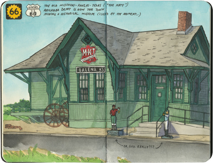
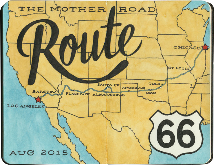
Logically, if you were to plan a trip from Chicago to Los Angeles, the shortest route would have you traversing Kansas to get there. Yet Route 66 carves out just 13 miles of road in the state’s southeastern corner, and does the bulk of its crossing of the Great Plains through Oklahoma instead. Why, you ask? Well, that’s an interesting story. The man responsible for plotting the Mother Road’s path, Cyrus Avery, called Tulsa home. He wanted to show off his state in all its glory, so he made Route 66 both a tour guide and a monument to Oklahoma, with over 400 miles of pavement to draw travelers and tourist dollars there. Still, Kansas gets a small slice of the action, and this gorgeous early-1900s train station does the Sunflower State proud.

There’s something else about this sketch that needs some explaining. See those small figures flanking the front steps? Yes, those are lawn jockeys. I could have just left them out of the sketch entirely, since I personally find lawn jockeys offensive and I hate to single out Galena. But I didn’t, because they bring up an uncomfortable truth about travel Americana, and the Mother Road in particular.

While it’s easy to get wrapped up in the nostalgia of olde-tyme family road trips and midcentury diners along Route 66, that part of American history is really only quintessential to the white population of this country. Black Americans, in particular, didn’t travel Route 66 the way white ones did. In many places, it simply wasn’t safe for them to do so. These places had a name that most of the nostalgic Mother Road literature seems to have forgotten: sundown towns.

Sundown towns—communities that barred people of color from the town limits after dark—were by no means confined to the South, nor did they exclude only African-Americans (my own city of Tacoma, WA expelled its Chinese residents in 1885). Sundown towns could be found everywhere from Connecticut to California, and even as late as the 1960s there were thousands of them. Thankfully Galena, as far as I can tell, was not among them—I should make that clear, since I’m already featuring that town in this post. Yet sadly, there were many sundown towns along Route 66—particularly in Oklahoma, Illinois, Missouri and California. In fact, for thirty years Black travelers relied upon the advice in The Negro Motorist Green Book, a guidebook printed between 1936 and 1964, which outlined which routes, communities, services, restaurants and lodging were willing to serve road-trippers of color. The Green Book mostly sent travelers well away from Route 66 and its many Jim-Crow-era dangers.

This history is all but scrubbed from the modern remnants of the Mother Road. If I hadn’t seen those lawn jockeys, I might not have thought to look into it myself. Yet unfortunately, there is also some fresh modern racism along 66. (We were particularly horrified by the large number of Confederate flags we saw along the route, mostly in western Arizona.) You’ll never see a sketch of that sort of thing on this blog, but I feel it’s important to note that it’s out there, that the Mother Road is not all neon and nostalgia. After all, you know what they say about those who don’t learn from the past.


Route 66 sketch by Chandler O'Leary

Farm to marketing

This post is part of an ongoing series called 66 Fridays, which explores the wonders of old Route 66. Click on the preceding “66 Fridays” link to view all posts in the series, or visit the initial overview post here.

One of the most well-known—and most-hyped—tourist traps along Route 66 are the Meramec Caverns. Whether or not the caves actually live up to the hype is not something I can weigh in on, I’m afraid: by the time we got there, they’d closed for the evening. But that’s okay—while I’m always up for a good tourist trap (neon signs inside the caves!), and I’d love to see the place that was allegedly the hideout of Jesse James, what really interests me most is the hype itself. And on our trip I didn’t have to worry about missing out on that.

Route 66 sketch by Chandler O'Leary

When it comes to advertising, Meramec Caverns seems to have taken a leaf from the playbook of Wall Drug, which opened just two years before the Caverns transitioned from local curiosity to tourist entertainment complex. Wall Drug had enormous success with advertising to travelers by way of hundreds of inexpensive, hand-painted wooden billboards placed in farm fields all over the northern Plains. Les Dill, the owner of the Caverns, offered farmers in 14 states a free paint job on their barns—as long as they were willing for the design to include a giant Meramec Caverns ad on whatever wall or roof panel faced the road. By the 1960s there were hundreds of Meramec barns in 40 different states, all beckoning travelers to the Ozarks.

Oh, and you might also be interested to know that Dill was also one of the earliest adopters of the humble bumper sticker, cottoning onto the idea of cars as mobile billboards. Now, I still don’t think there’s a more elegant bumper sticker than “Where the heck is Wall Drug?” but Meramec Caverns had the idea first.

Route 66 sketch by Chandler O'Leary

There are still a handful of Meramec barns around today, and some of the best (and most lovingly maintained) are along the Mother Road. They vary in design, and some—like the one above—look a bit like some sort of cryptic code for those in the know.

Well, thanks to Dill’s ingenious marketing strategy, I am in the know now—and you can bet I’ll return one day, following the signs back to the Caverns, barn by barn.

Route 66 sketch by Chandler O'Leary

Ted’s tasty freeze

This post is part of an ongoing series called 66 Fridays, which explores the wonders of old Route 66. Click on the preceding “66 Fridays” link to view all posts in the series, or visit the initial overview post here.

Our first day on Route 66 was bookended with pit stops at iconic Mother Road road-food joints. We had our early-morning breakfast at Lou Mitchell’s just after sunrise, but by the time we reached St. Louis in the late afternoon, it was so hot and muggy that we were dying for a break to cool off. Enter Ted Drewes, to the rescue.

Route 66 sketch by Chandler O'Leary

Ted’s recipe for frozen custard has been an icon since 1926, and the location on Chippewa Street has been a Route 66 fixture since it opened in 1941. There were plenty of treats to choose from, but we went with their classic mainstay, the Concrete. To anyone who has visited a Dairy Queen in the last thirty years, a Concrete will look just like ye olde familiar Blizzard. The Blizzard, too, was invented in St. Louis—but Dairy Queen will be the first to admit that the inspiration was Ted Drewes’s concoction, which predated the Blizzard by nearly thirty years.

I went with the fairly standard cookie dough flavor for mine, but the Tailor just about died of happiness when he saw they offered one made with pie cherries (his favorite, and an increasingly rare commodity—that’s a story for another day). We still had another eighty miles of road ahead of us that day, but we were refreshed and ready: nothing prepares you for pounding the pavement like a little scoop of Concrete.

Lou Mitchell's sketch by Chandler O'Leary

The first stop

This post is part of an ongoing series called 66 Fridays, which explores the wonders of old Route 66. Click on the preceding “66 Fridays” link to view all posts in the series, or visit the initial overview post here.

If you’re going to start Route 66 in Chicago, start your trip right with a meal at Lou Mitchell’s diner. Nicknamed the “first stop on the Mother Road,” I can’t think of a better place to break your fast or mark the beginning of a journey. Also, since the place opens at 5:30 on weekday mornings, you don’t have to derail your whole day with a stop here. (Tangent! One of my few complaints about living on the West Coast is that nothing opens early. A huge thing I miss about Midwestern living is being able to run errands and go out to eat at the crack of dawn!)

Lou Mitchell's sketch by Chandler O'Leary

And if you go, you best come hungry. Not only are the plates enormous (double-yolk eggs!), but even the simplest breakfasts turn out to be five-course meals there. Leave room for the doughnut holes, is all I’m saying.

Lou Mitchell's sketch by Chandler O'Leary

Now, the food and history are reason enough to eat at Lou Mitchell’s. But the icing on the proverbial cake, for me, was the lettering. Hoo boy, there is more gorgeous, vintage, hand-painted sign lettering in there than can be found in some entire cities. I thought I’d died and gone to heaven.

Lou Mitchell's sketch by Chandler O'Leary

All I can say is thank goodness this place is still here, still largely untouched. It seemed like a good omen for embarking on an Americana pilgrimage. Long live Route 66, long live Lou Mitchell’s.

Route 66 sketch by Chandler O'Leary

Eastern terminus

This post is part of an ongoing series called 66 Fridays, which explores the wonders of old Route 66. Click on the preceding “66 Fridays” link to view all posts in the series, or visit the initial overview post here.

To help you keep your bearings in this 66 Fridays series, and to provide an overview of the route, the first few posts will go in geographical order. So let’s start at the very beginning, at the eastern terminus of the route.

American highways, in general, are measured from south to north, and from west to east. So in general, the “start” of any highway is technically its southern- or westernmost point, and the milemarkers count from there. But for our Route 66 trip we went from east to west. That’s because for that highway, at least, most travelers (from Dust Bowl migrants to pleasure cruisers) seemed to head that direction. All the Route 66 lore, from songs to stories, seems to be oriented that way, too. And besides, America is steeped in the tradition of heading West—to me, the East still feels like a beginning, and the West a promise of what lies ahead.

So that put the beginning of our journey at the beginning of the route: in downtown Chicago.

Chicago sketch by Chandler O'Leary

Route 66’s path through Chicago has changed somewhat over the years, but that’s a longer story than necessary for this post. To make things simpler, most travelers and historians count Michigan Avenue, between Adams and Jackson, as the eastern terminus of the Mother Road. (Adams is a one-way heading west, and Jackson is the same eastbound, hence the two intersections.) And there are no better guardians of the route than the bronze lions prowling in front of the Art Institute.

Chicago sketch by Chandler O'Leary

It’s even more fitting when you consider that the Art Institute was originally part of the 1893 World’s Columbian Exposition. A sort of World’s Fair, the Exposition marked 400 years since Christopher Columbus landed in the New World, and celebrated the rebirth of Chicago after the Great Fire of 1871. Most of the buildings erected for the Exposition were designed to be temporary, but the Art Institute was intended to occupy what was the World Congress Auxiliary Building at the fair, so that structure was made permanent.

Oh, and incidentally, the Art Institute of Chicago was originally called the Chicago Academy of Design, which was founded in 1866. Its address before the Great Chicago Fire? 66 West Adams Street.

Route 66 sketch by Chandler O'Leary

Somehow, then, it seems pretty perfect that an old WCE building, originally designed to promote westward exploration and new beginnings at the fair, marks the beginning of America’s best-known westward highway.

Route 66 sketch map by Chandler O'Leary

Mother Road, mother lode

Last summer the Tailor and I spent a couple of weeks traveling every inch of old Route 66. And then I kept pretty quiet about it, because I just had no idea how to organize and share the sheer number of sketches and stories I came away with afterward. There really is no “long story short” way to do this—like the Mother Road itself, there are too many branches and tangents for a single linear tale. So like I did for my Mission Mondays series, I’m going to break this down into 66 Fridays, starting today and running through spring of next year. (You can follow along by using the 66 Fridays tag.)

So each week for the next 66 weeks, I’m going to share a piece of Route 66—and like everything else on this blog (except the Mission series), those pieces will be in no particular order. There are a zillion books out there already that tell the Route 66 story from beginning to end (both in time and space), so that frees me to, er, paint a slightly different picture. I’ll be jumping around from state to state, highlighting my favorite landmarks and historical tidbits. With any luck, it’ll give you a good enough taste of the Mother Road that it’ll inspire you to explore it for yourself.

Route 66 sketch by Chandler O'Leary

A few notes:

• There’s a common perception that Route 66 is long gone, and that modern travelers can only drive bits of the route. That’s actually not true. While modern Interstate highways have replaced long chunks of the Mother Road in certain spots, it’s actually possible to drive over 80 percent of the original route—including the original road bed and even 90-year-old pavement in several places. Route 66 was officially decommissioned as a U.S. highway decades ago, but the old thread is still there, still nearly intact, just waiting for an adventurous traveler with a sharp eye to find it.

• We didn’t see everything there is to see on Route 66. Not even close. We spent nearly two weeks on the Mother Road, and by my estimate we would have needed a good month, at least, to really take it all in. Considering how much more there would have been to see years ago, before so many places closed down or fell into ruin, it all boggles my mind a bit. Nevertheless, this trip was a good first taste of the whole thing. I made the Tailor promise me that someday we’d do it all again, and take however much time we wanted.

• Even though we didn’t see everything along the way, we did our darndest to drive every inch of the route that remains—and that’s no small feat, considering how many tributaries, diversions, parallel routes, rerouted sections, poorly-marked bits and dead ends there are. I’d driven bits of 66 before, but never the whole stretch in one go. It feels like a real accomplishment that we did that.

• I hope you don’t hate vintage signs, because you can expect a lot of them in the coming months. I’ll try to keep the posts balanced between various subject matters, but I’m not gonna lie: there’s a metric ton of incredible vintage signage along Route 66, and I did my level best to draw all of it. I have whole sketchbooks just devoted to neon. I probably won’t show you everything, but you will see an awful lot of it.

Route 66 sketch by Chandler O'Leary

So buckle your seatbelts and pull out your paper maps—let’s get this show on the road, and embark upon the serious business of getting our kicks.

Save